
Taichung City Government
feature
Taichung city government has developed its digital blueprint for the city with the vision of "convenience, efficiency, and co-creation" in mind. With “Enhancing Service Experiences for citizens”, “Strengthening Administrative Efficiency of government”, and “Facilitating Public-Private Partnerships and Mass Participation” as the primary goals, the city government will deploy plans under the guidance of following 10 strategies:
- Establishing a Smart Citizen Platform, which integrates municipal services.
- Enhancing the applications of digital technologies for 24/7 citizen services.
- Developing O2O Services that provide citizens with seamless experiences.
- Developing data exchange standards and establishing a mechanism for open and shared systems.
- Integrating resources to strengthen information security.
- Deploying IoT Infrastructure and making good use of Big Data to support municipal decision-making.
- Leveraging digital marketing to communicate policies precisely to citizens in need.
- Facilitating Public-Private partnerships for city’s innovative and sustainable development.
- Promoting open data usage while carefully taking privacy protection into account.
- Encouraging citizen participation in city governance through online platform.
The strategies presented propel Taichung’s development into the next stage of innovation and livability, making Prosperous Taichung, Delightful Life" come true.
solution
630
0
Smart Governance
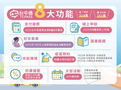
TCPASS
TCPASS app provides a comprehensive integration of municipal services, including mobile payments, "Maternity Taxi" bookings, vaccine appointments, online applications, event calendars, and various welfare updates. Members can use their Digital Citizen Card to access exclusive discounts at over 1,500 partner stores across Taichung and Nantou, including famous chain brands, local delicacies, and Top 10 Souvenir shops. TCPASS has become a highly acclaimed tool, making diverse digital services effortlessly accessible to all citizens.
422
0
Smart Governance
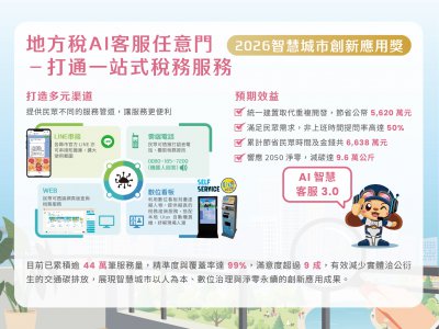
TAX AI "ANYWHERE DOOR": A SEAMLESS ONE-STOP TAX SERVICE
The Taichung Local Tax Bureau has launched the "Local Tax AI Anywhere Door," a 24/7 intelligent service platform powered by AI and Natural Language Processing (NLP). By integrating local, national, and cross-agency data, the system utilizes Deep Learning (BERT) and a specialized tax knowledge base to provide precise, multi-turn conversational consultations. The platform also features online applications, tax simulations, e-payments, and live text/video support, drastically reducing processing time and costs for citizens. To date, it has served over 440,000 cases with 99% accuracy and over 90% satisfaction, effectively lowering transportation-related carbon emissions and demonstrating the power of human-centric digital governance.
 、Firefox
  、Edge
、Edge  瀏覽器!
瀏覽器!