Civil IoT Taiwan
Civil IoT Taiwan is part of the government’s Forward-looking Infrastructure Development Program under the Digital Construction initiative. With the collaborative efforts of the National Science Council, Ministry of Environment, Ministry of Economic Affairs, Ministry of Agriculture, Ministry of Transportation, Ministry of the Interior, Ministry of Digital Affairs, and Academia Sinica, the project is jointly executed across departments, prioritizing four key areas: air quality, water resources, earthquakes, and disaster prevention and response. By leveraging artificial intelligence and IoT technologies, various smart living services are developed to assist the government and the public in jointly addressing the challenges brought by environmental changes. By combining the innovative power of industry, academia, and research, the project aims to develop the IoT industry ecosystem and export solutions internationally.
Digital Twin Technology: A Comprehensive View of Disaster Impact
Solution Description
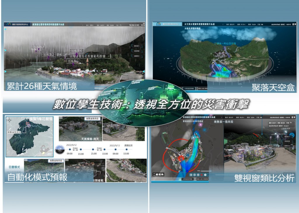
The application of digital twin technology in building smart cities is becoming increasingly clear, serving as a crucial engine for driving urban transformation. In the development of smart cities in recent years, citizens can view the growth and development of the entire city, including population growth, new construction, and other major activities, in a 3D format, gradually emphasizing the concept of a virtual city. Digital twin technology can simulate disaster scenarios, including weather events and traffic accidents, assisting disaster response personnel in rapidly understanding the situation and optimizing the efficiency of disaster response. In recent years, with the advancement of aerial photography, simulation technology, and computing resources, The National Science and Technology Center for Disaster Reduction has leveraged advanced technology to create a mountainous flood inundation model system. This system enhances disaster warning and impact analysis, providing a comprehensive view of vulnerable settlements. It utilizes dynamic models and virtual-real integration, presenting alert information and disaster impacts through visual elements, contributing to informed decision-making in disaster situations.
Download
Solutions


 、Firefox
  、Edge
、Edge  瀏覽器!
瀏覽器!