solution(180)
imedtac Co., Ltd.
397
0
Smart Healthcare
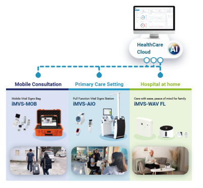
HaH (Hospital at Home)- Telehealth Solution
Telehealth solution is a deployable, end-to-end mobile care platform built for cross-site clinical delivery. Borderless Care extends professional healthcare to rural communities, offshore islands, and long-term care facilities. At its core, the IoMT Data Hub integrates medical-grade devices and seamlessly connects with HIS/EMR systems, enabling real-time cloud synchronization. This drives Clinical Efficiency by giving clinicians instant access to patient records and live vital data during video consultations—supporting faster, more accurate decision-making. Designed for the field, Ultimate Mobility adds military-grade protection with waterproof and shockproof durability, plus satellite connectivity to ensure reliable operation even in hard-to-reach areas.
Delta
3.90k
1
Smart Energy Saving
Smart City Solutions
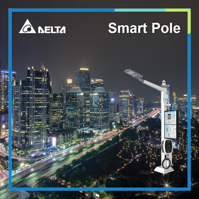
Delta's smart city solutions are based on three main axes: smart park management, smart light poles, and community security monitoring: smart park management uses a cross-system city information integration platform that handles a wide range of data transmission, aggregation, visualisation, and analysis to help achieve the goals of smart city governance. Intelligent light poles provide low-carbon lighting services in the parks, and at the same time serve as information collection and transmission nodes for the intelligent Internet of Things, while security surveillance protects people and assets in the parks and the city from infringement. Delta's smart city solutions help customers achieve a better smart city with both technology and humanity.
TP-LINK TAIWAN CO., LTD.
719
0
Smart Governance
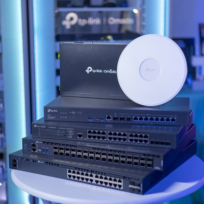
High-Density Network Integration Solution for Large-Scale Esports Events
During WirForce 2024, the largest LAN Party in Asia, the Omada business networking solution provided full network support for 1,400 BYOC players. Over four days, the network handled more than 6,000 wired devices and 800 wireless devices, with total data traffic exceeding 1,800TB, demonstrating exceptional performance and reliability.
Through the Omada centralized cloud management platform, network administrators were able to monitor network status in real time, rapidly identify issues, and maintain high-speed, stable connectivity throughout the event.
Key components included EAP773 Wi-Fi 7 access points, delivering BE11000 ultra-high-speed connections and seamless roaming, along with high-performance L2/L3 switches supporting 10G throughput and PoE power to ensure stable data transmission under extreme traffic loads. An OC300 hardware controller enabled real-time monitoring and flexible network management.
By successfully addressing the challenges of ultra-high density and massive traffic demand, Omada and WirForce jointly delivered a premium esports networking experience.

Taiwan AI Cloud Corporation
1.83k
0
AI / AIoT
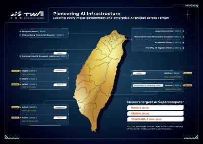
AI Compute Foundry
Taiwan AI Cloud AI Compute Foundry solution provides one-stop AI infrastructure services.
Assist governments, enterprises, and the global GPU market in driving the development of sovereign AI.
Empower enterprises to build customized AI compute centers with their own AI infrastructure, data governance, and model operation environments.
We provide complete AIHPC deployment, integration, and maintenance services, supporting private, public, and hybrid cloud architectures.
Fashion Intelligence Co.,Ltd.
3.25k
0
Smart Manufacturing
Intelligence on People Seeking
This service can avoid children and elders being lost. Users merely have to bring the device with them, through the sensor installed at the service area, family members can immediately receive users’ instant position through exclusive website, LINE or App.
【Real-time Positioning】
The caregiver can dynamically query and know about the real-time location and the path data for each care receiver.
【Guarding Area】
The caregiver can set different areas as guarding areas, and they will be notified if any care receiver enters or leaves these areas.
SUNMADE INC.
2.28k
1
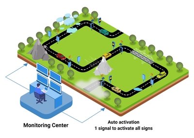
Smart Transportation
Traffic approach warning system
Traffic approach warning system is the combination of smart detectors and LED warning signs. The intersection is divided into detection lanes and warning lanes. Smart detectors are installed on the detection lanes. When a vehicle enters the detection area, the signal is transmitted to activate the LED signs on the warning lane to warn drivers to slow down in advance.
Taipei City Government
73.41k
0
Other
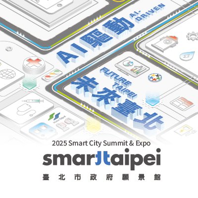
Taipei Pavilion:AI-Driven -Future Taipei
The Taipei Vision Pavilion, themed "AI-Driven · Future Taipei," showcases Taipei's transformation into a "Safe City," "Sports City," and "Future City." By leveraging cutting-edge technologies such as artificial intelligence, big data, and Internet of Things, the pavilion highlights various smart city applications, including smart transportation, technological disaster prevention, AI-driven healthcare, and smart education. We sincerely invite you to join us and experience firsthand how AI is shaping the future of Taipei, setting a new benchmark for smart cities!
Far EasTone Telecommunications Co., Ltd.
509
0
Smart Transportation
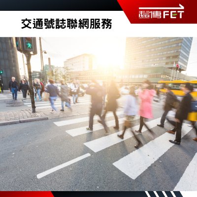
Traffic Signal Mobile Communication Service
Far EasTone’s Traffic Signal Mobile Communication Service makes urban intersections smarter and safer! With the stable connectivity of Far EasTone’s network, traffic control centers can not only monitor signal status in real time and adjust timing remotely, but also optimize signal control based on dynamic traffic flow, enabling smoother travel and reducing congestion.
At the same time, we place pedestrian safety at the core. In response to the “pedestrian hell” issue, the system supports pedestrian signal control—such as extending pedestrian green time or inserting additional phases—and works in tandem with smart intersection sensing devices to proactively protect every step pedestrians take while crossing the street.
Kaohsiung Medical University
494
0
Smart Healthcare
An Auxiliary Assessment System for Coronary Heart Disease Identification
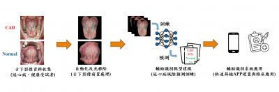
Dr. Hung-Lung Lin’s Team – An Auxiliary Assessment System for Coronary Heart Disease Identification
In response to population aging and the younger onset of coronary heart disease (CHD), this study develops an AI-based auxiliary CHD screening system integrated into a mobile app. Grounded in traditional Chinese medicine tongue–heart theory, the system analyzes sublingual vascular images using reflection removal, image segmentation, and a multi-head attention deep learning model. Users can obtain accurate, reproducible screening results and health recommendations within 7–20 seconds using only a smartphone, enabling convenient and cost-effective preliminary CHD assessment.
SOYAL Technology Co., Ltd
442
0
Smart Energy Saving
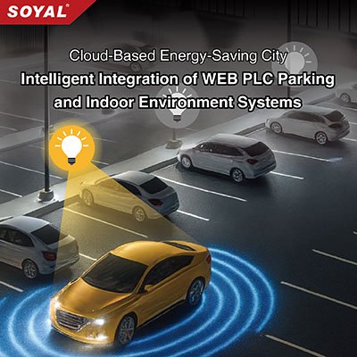
Cloud-Based Energy-Saving City | Intelligent Integration of WEB PLC Parking and Indoor Environment Systems
SOYAL Smart Parking Lighting System integrates RFID and infrared sensing to automatically pre‑light target spaces upon vehicle entry, while dynamic “lights follow the car, off when it passes” guidance ensures safety, efficiency, and energy savings for low‑carbon smart parking. The WEB PLC Air‑Conditioning Control System uses DI sensors to detect occupancy and temperature differences, adjusting indoor climate on demand to optimize building energy performance and support carbon‑reduction goals. The WEB PLC Office Lighting Control System combines card recognition with infrared sensing to maintain uninterrupted lighting when staff are present, then provides a five‑minute buffer before shutdown after work hours, with secondary detection to confirm departure. This precise energy management maximizes the value of every kilowatt. Together, these three systems highlight the advantages of smart building automation—delivering comfort, safety, and sustainability.
Taiwan International Development Co.
354
0
Smart Transportation
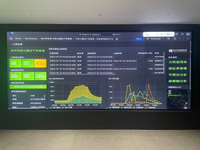
From Sensing to Decision-Making: Building a City Where Parking Talks
Breaking Traditional Boundaries: Building Urban Traffic Neural Networks
Taiwan International's flagship Cloud Governance Platform completely revolutionizes conventional parking management models. The platform successfully integrates diverse smart devices including In-Ground Magnetic Sensors, Smart Parking Posts, and Overhead Camera Systems through a unified API management architecture, achieving seamless cross-brand and cross-regional data interoperability that enables cities to truly "think."
"Every device serves as a crucial node in the city's traffic neural network," emphasized Taiwan International. Smart parking represents not merely a technological upgrade, but a fundamental transformation in urban governance models. Through the cloud platform's big data analytics and AI deep learning capabilities, city managers can transition from reactive responses to proactive predictions, achieving genuine intelligent decision-making.
 、Firefox
  、Edge
、Edge  瀏覽器!
瀏覽器!