solution(180)
Kaohsiung Medical University
522
0
Smart Healthcare
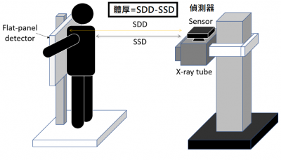
Intelligent X-ray Imaging System
Prof. Ming-Chung Chou’s Team – Intelligent X-ray Imaging System
Traditional X-ray imaging depends on experienced radiographers to balance image quality and
radiation dose. Automatic exposure control may misjudge patients with poor positioning or metallic
implants, increasing radiation by about 20%. This study develops an AI-based X-ray imaging system
with non-contact body thickness measurement. By integrating patient height and weight, the system
automatically determines optimal exposure parameters, ensuring stable image quality while reducing
unnecessary radiation and cancer risk.
Kaohsiung Medical University
494
0
Smart Healthcare
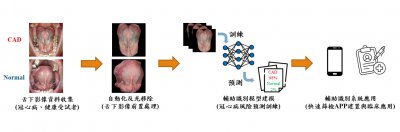
An Auxiliary Assessment System for Coronary Heart Disease Identification
Dr. Hung-Lung Lin’s Team – An Auxiliary Assessment System for Coronary Heart Disease Identification
In response to population aging and the younger onset of coronary heart disease (CHD), this study develops an AI-based auxiliary CHD screening system integrated into a mobile app. Grounded in traditional Chinese medicine tongue–heart theory, the system analyzes sublingual vascular images using reflection removal, image segmentation, and a multi-head attention deep learning model. Users can obtain accurate, reproducible screening results and health recommendations within 7–20 seconds using only a smartphone, enabling convenient and cost-effective preliminary CHD assessment.
StarTrust System Inc.
2.28k
0
Net-Zero Consulting
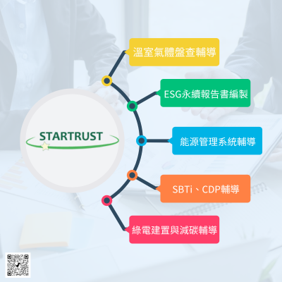
Sustainable consulting services
StarTrust System boasts a proficient team of consulting experts, each holding certifications in ISO 14064-1, ISO14067, ISO 50001, ISO 14001, SBTi, GRI Standard, and other relevant standards. We offer comprehensive guidance services encompassing greenhouse gas inventories (ISO 14064-1, GHG Protocol), carbon footprint assessments (ISO 14067), and advisory support for international initiatives such as CDP and SBTi. Additionally, we provide consultancy expertise in ESG report preparation, energy management, carbon neutral, and carbon reduction strategies.
To ensure data integrity, our consulting team at StarTrust System adopts systematic management practices. We meticulously organize activity documents, regulations, calculation parameters, and other pertinent data, ensuring timely updates to adhere to the latest regulations and calculation methodologies. Our approach mitigates complexities and minimizes the risk of errors in enterprise reporting operations.
Our services include:
1. Comprehensive guidance on ISO 14064-1, GHG Protocol, and related assessments.
2. Expert support for ISO 14067 product carbon footprint assessments.
3. Advisory services for implementing ISO 50001 energy management systems.
4. Analysis of carbon emission data reports.
5. Assistance with international initiatives such as CDP and SBTi.
6. Professional preparation of ESG sustainability reports.
Taipei City Government
4.98k
0
Other
Smart Environment
Due to the terrain of Taiwan, how to save water resources become one of the main topics that has attracted the public’s attention. Through the following water facilities, the public could get real-time query of water information. In the future, water alarms will be provided for the public to prevent water disaster. At the same time, it also makes water resources management more intelligent, which can not only save resources but also effectively control them.

T-Global Technology
723
0
Smart Grid
Heat dissipation of the server is a crucial factor in ensuring stable system operation.
With the emergence of technologies such as 5G, the Internet of Things, Artificial Intelligence and Cloud Computing in recent years, the server industry has experienced explosive growth. In line with the two major trends of "software definition" and "open standards," private industry and governments are collaborating to promote numerous high-tech research projects and the development of critical technologies. As the cloud industry chain continues to evolve, the annual power consumption of data centers, which are made up of numerous individual servers, increases greatly. Consequently, the effective thermal management of servers and data centers has become an increasingly crucial issue.
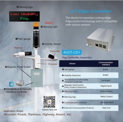
HI-POWER SOLUTION CO., LTD.
4.27k
1
Smart Energy Saving
IOT Edge Controller
The device incorporates cutting-edge Edge control technology and is compatible with various sensors.
• Independent Operation
The device can operate independently even when powered off or disconnected from the network, ensuring continuous operation
and functionality.
• Remote Firmware Update and Configuration
It allows for remote updating of firmware and configuration settings over the network, enabling easy maintenance and optimization of
the device.
• Data Storage and Transmission
The device is equipped with capabilities for storing and transmitting data, facilitating the collection and transfer of information as needed.
• LED Indicators
The device is equipped with LED indicators for power and communication status, providing visual feedback on its operational status.
1.Model No: AIOT-C01 Fog Detection Controller
Application Scope: Mountain Roads, Railways, Highway, Airport, etc
2.Model No: AIOT-C02 Rainfall Detection Controller
Application Scope: Mountainous Area Water Level and Rainfall.
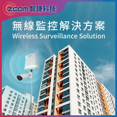
Z-COM, Inc.
2.04k
0
Smart Security
Wireless Surveillance Solution
The need of video surveillance has increased with the issues of campus, public places security and intelligent transportation. What’s more, high-resolution image, identification, analysis and AIoT applications are getting popular than before. People are strict in the performance of transmission and computing.
Internet communication technology has entered a new era as well.
To achieve intelligent service, zMEC ’s platform as service through Kubernetes-based architecture which can not only integrate with the third-party but also expand different AIoT software application modules, such as identification and analysis, electronic fence.
Besides, the technology of edge computing can reduce the demand of video and audio data for cloud center computing access and network bandwidth resources, so as to make up for the problem of traditional cloud computing delay and unsafe transmission link. It meets the need of high frequency bandwidth and low latency, and to satisfy the needs of information security and privacy protection.
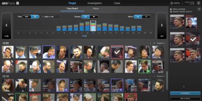
AIRA Corporation
2.45k
0
AI / AIoT
airaTrack- Facial Tracking Solution
airaTrack is a comprehensive personnel tracking system that utilizes AI algorithms developed by our team to extract features from both the "face and figure." It generates unique biometric IDs with a recognition accuracy of up to 99%, all without the need for registering facial data, addressing privacy concerns. Capable of cross-camera searches and matching 10,000 faces per second, it significantly enhances the efficiency of traditional manual matching processes and increases search efficiency and accuracy by 97% enabling automatic path tracking of personnel in the field. The system also generates investigation reports for evidential preservation.

Climate Change Administration,Ministry of Environment
2.55k
1
Circular Economy
Transforming Textile Waste into Sustainable Recycled Materials
Strong and Wise Materials Technology offers a solution for transforming textile waste into high-value products, promoting low-carbon sustainability and environmental protection. Not only does this solution address the pollution caused by textile waste in urban areas, but it also aids brands and the textile industry in managing over 90% of their textile waste.
Through patented technology, we convert textile waste into high-quality recycled plastic (R-PET) particles for various recyclable plastic products. Additionally, we produce environmentally friendly green building materials (EF Wood) suitable for different environments, resolving issues associated with solid wood and plastic wood while creating a variety of wood-like furniture. All our products are 100% recyclable.
Strong and Wise provides truly sustainable and circular solutions, generating renewed value from textile waste.

TP-LINK TAIWAN CO., LTD.
719
0
Smart Governance
High-Density Network Integration Solution for Large-Scale Esports Events
During WirForce 2024, the largest LAN Party in Asia, the Omada business networking solution provided full network support for 1,400 BYOC players. Over four days, the network handled more than 6,000 wired devices and 800 wireless devices, with total data traffic exceeding 1,800TB, demonstrating exceptional performance and reliability.
Through the Omada centralized cloud management platform, network administrators were able to monitor network status in real time, rapidly identify issues, and maintain high-speed, stable connectivity throughout the event.
Key components included EAP773 Wi-Fi 7 access points, delivering BE11000 ultra-high-speed connections and seamless roaming, along with high-performance L2/L3 switches supporting 10G throughput and PoE power to ensure stable data transmission under extreme traffic loads. An OC300 hardware controller enabled real-time monitoring and flexible network management.
By successfully addressing the challenges of ultra-high density and massive traffic demand, Omada and WirForce jointly delivered a premium esports networking experience.
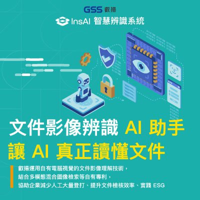
Galaxy Software Services Corporation
458
0
E-Office
InsAI
InsAI: Beyond Traditional OCR.
InsAI is an intelligent recognition system that allows AI to truly read and understand real-world documents. By utilizing GSS’s proprietary Computer Vision and patented multi-modal retrieval technologies, InsAI transforms document processing. We help enterprises eliminate repetitive manual entry and streamline verification, paving the way for paperless operations and ESG compliance.
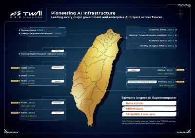
Taiwan AI Cloud Corporation
1.83k
0
AI / AIoT
AI Compute Foundry
Taiwan AI Cloud AI Compute Foundry solution provides one-stop AI infrastructure services.
Assist governments, enterprises, and the global GPU market in driving the development of sovereign AI.
Empower enterprises to build customized AI compute centers with their own AI infrastructure, data governance, and model operation environments.
We provide complete AIHPC deployment, integration, and maintenance services, supporting private, public, and hybrid cloud architectures.
 、Firefox
  、Edge
、Edge  瀏覽器!
瀏覽器!