solution(180)

Trade-Van Information Services Co.
409
0
AI / AIoT
Trade-Van AI Family
Trade-Van integrates big data governance capabilities with discriminative and generative AI technologies to build an enterprise-grade AI application platform that helps government agencies and enterprises achieve process automation, intelligent decision-making, and optimized risk management.
Through AI-driven document recognition, intelligent agents, and automated customer service systems, organizations can effectively reduce manual operational costs, shorten processing time, and improve decision-making efficiency and service quality.
The AI Family serves as a new engine for intelligent governance, creating a secure, stable, and continuously evolving smart operational environment.
Service Offerings:
readAI – Intelligent image and document recognition
thinkAI – Intelligent agent applications
Smart Customer Service System
Delta
3.90k
1
Smart Energy Saving
Smart City Solutions
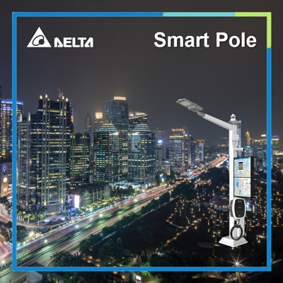
Delta's smart city solutions are based on three main axes: smart park management, smart light poles, and community security monitoring: smart park management uses a cross-system city information integration platform that handles a wide range of data transmission, aggregation, visualisation, and analysis to help achieve the goals of smart city governance. Intelligent light poles provide low-carbon lighting services in the parks, and at the same time serve as information collection and transmission nodes for the intelligent Internet of Things, while security surveillance protects people and assets in the parks and the city from infringement. Delta's smart city solutions help customers achieve a better smart city with both technology and humanity.
Yunlin County Government
2.77k
0
Smart Award
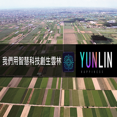
Creating six-tier industrial AI technology demonstration field in the central and southern regions-Yunlin Digital Transformation and Creation Service
Nearly one-third of the population in Yunlin County are first-tier industrial workers, mainly agricultural planting and fishery breeding. Through the inventory of various key program modules of scientific and technological agriculture and through service and product design, the six-tier digital system has been completed. It has been effectively improving the first-tier Industrial productivity and filling the gap in production instability, and receiving a solution for the lack of labor and the approval of the National Development Council Plan. This will also make Yunlin a place where cases of digital transformation and creation blooming. This service is introduced into multiple towns and villages in Yunlin County and 350 jobs have been created and about 320 million production value have been increased.The project won the 2022 “Smart City Innovation Application Awards".
CyCraft Technology
514
0
AI / AIoT
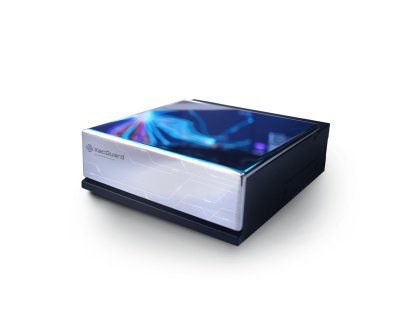
XecGuard Next-Generation AI Firewall
- Zero-Code AI Security
Enable enterprise-grade protection via an OpenAI-compatible API—no code changes required. Instantly defend against Prompt Injection and PII leakage.
- Flexible Enterprise Guardrails
Supports Inline and Shadow modes with Prompt & Response Guardrails to detect and block risky interactions in real time.
- Scalable AI Governance
Built for scale with auto-scaling, multi-tenant management, and seamless SIEM/SOC integration via Alert APIs.
TECO
4.68k
1
Smart Home
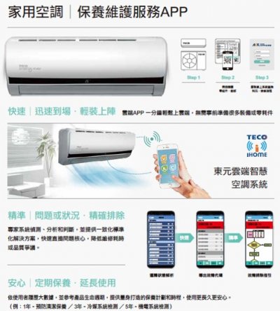
TECO Cloud Air Conditioning Operation And Maintenance System
TECO develop Air conditioners base on the core vision of ” Energy Saving , Emissions Reduction, Intelligent Operation, Automation” in order to provide total AIoT solutions.
Our residential air condition series apply “Smart maintenance system” which could inspect operation status/ collect data /diagnose issues and provide appropriated troubleshooting suggestions proactively and precisely. The system utilizes expert system not only solve issues but also initiate a tailor-made service plan in a shorter time with less manpower.
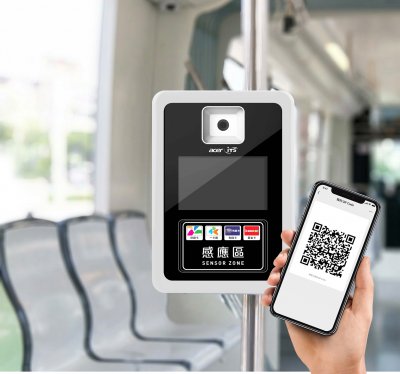
Acer ITS Incorporated
2.63k
1
Smart Transportation
Multi-Payment Validator
Multi-payment bus validator takes smart card, mobile payment for bus fare. The transaction data transfer through designated channel to the backend system, smart card issuers, mobile payment operators to perform clearance process. All the validators comply with operation standards and receive certification from smart card issuers, mobile payment operators and TTIA.
Taiwan AI Cloud Corporation
1.89k
0
AI / AIoT
AI Model Foundry
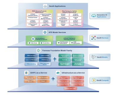
Taiwan AI Cloud provides industry-specific AI application integration services, including custom LLM model fine-tuning, AI deployment planning, and AI training and inference platform development. Built on the Formosa Foundation Model (FFM) — an enterprise-grade large language model optimized for local languages and industries — or other high-performance open-source models, our solutions enable organizations to systematically integrate AI into real-world operations. Through expert consulting and tailored implementation, we help enterprises enhance operational efficiency, optimize customer experience, innovate business models, and build sustainable AI capabilities that drive long-term digital growth.
Kaohsiung City Government
3.48k
0
Smart Transportation
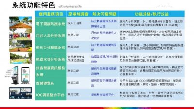
The Integration Service of Intelligent Rail Protection System
The system developed by this project provides a smart solution for station including digital fence system, platform pedestrian flow analysis, animal tracking expelled system, track water situation analysis system and platform digital information signage. The platform comprehensively analyses the image of around the station, train coordinates, passenger entry and exit, and water depth etc. Which can be used for follow up review and improvement of abnormal events such as track intrusion, crowd congestion and road flooding to achieve optimal train operation configuration and class spacing control. And provide abnormal event warning and troubleshooting and passenger intelligence information services. After the integration of multiple subsystem through the IOC platform, the system will automatically alert an alarm to the traffic control center and announce the train near the area to remind the driver to pay attention to the situation and enhance the safety of the train and the people or cars in the area when the detection system alarms.

HwaCom Systems, Inc.
2.64k
0
Smart Manufacturing
Remote Expert Video Collaboration Solution
Remote expert video collaboration solution uses AR smart glasses to transmit onsite situation to the remote technical experts with high-definition real-time video, and guide the on-site engineer to troubleshoot and repair the fault from the first-person view perspective and free their hands. This is not only improves maintenance efficiency, but also ensures safety. It also achieve the sharing and inheritance of expert resources and high cost of traveling on site. When encountering difficult situations, multiple technical experts can also be invited for consultation. Experts can provide real-time multi-party HD video guidance with the on-site engineer, whether on PC or smartphone, to jointly solve technical issues and reduce downtime losses.
EUPFIN Technology Co.
2.34k
0
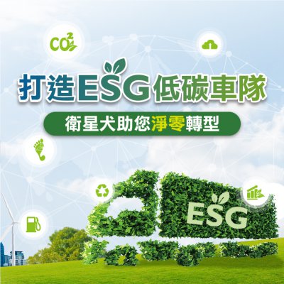
ESG
ESG Solution
The EUP Fleet Management System integrates ESG management, providing visualized reports and big data analysis to accelerate communication between the supply chain and transporters, ensuring effective ESG management and achieving carbon reduction goals. Through AI big data analysis, it automatically provides green ratings and compares carbon emissions with industry peers, enhancing market competitiveness and brand image. Additionally, cloud-based, digital, and automated management enables enterprises to easily monitor fleet emissions and develop carbon reduction strategies.
HI-POWER SOLUTION CO., LTD.
2.41k
0
Smart Transportation
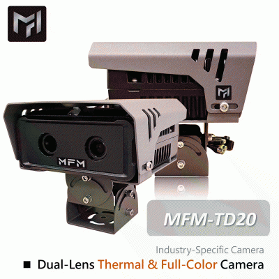
Dual-Lens Thermal & Full-Color Camera
Feature
•Automatic Gain Control (AGC).
•Backlight Compensation.
•Automatic White Balance.
•Wide Dynamic Range (WDR) function with 120dB at 30 FPS.
•Night noise suppression function.
•Nighttime shooting with automatic aperture adjustment.
•Stable image quality during low-light shooting at night under stable external light conditions, ensuring no flicker or color rolling, and clear nighttime images.
Specifications
•Uses a CMOS 1/3” Image Sensor.
•MAX Resolutions:2MP (1920×1080 pixels),D1 (640x480 pixels)
•Maximum Frame Rate:30 FPS @1920×1080,30 FPS @640x480
•Focal Length:2MP lens : 2.8-12mm±5%,D1 lens : Fixed
•Minimum Illumination:Color: Below 0.06 Lux,Black:Below 0.02 Lux.
A-MTK Co., Ltd.
2.79k
0
Smart Transportation
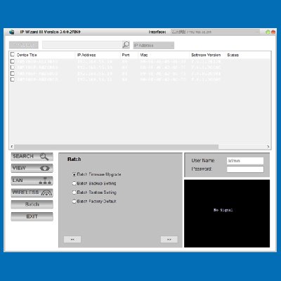
A-MTK provides IP camera management tool named “IP Wizard III”
A-MTK provides IP cam management tool named “IP Wizard III”for customers to manage a large number of IP cams quickly and easily. A-MTK provides following management functions:
1. Check the status and remaining capacity of the mSD card in the camera.
2. one-click to bring back various parameters of the camera: to facilitate backup and transfer to a new camera
3. Batch change IP cam image parameters, such as image compression, number of sheets, bitrate, etc.
4. batch change IP cam password: to facilitate regular password changes to meet information protection needs
5. A-MTK Camera can actively report log records, and at the same time provide CGI for the platform to capture log reports, and can be batch capture.
 、Firefox
  、Edge
、Edge  瀏覽器!
瀏覽器!