solution(180)
SDS-System Design Service
488
0
Smart Environmental Protection
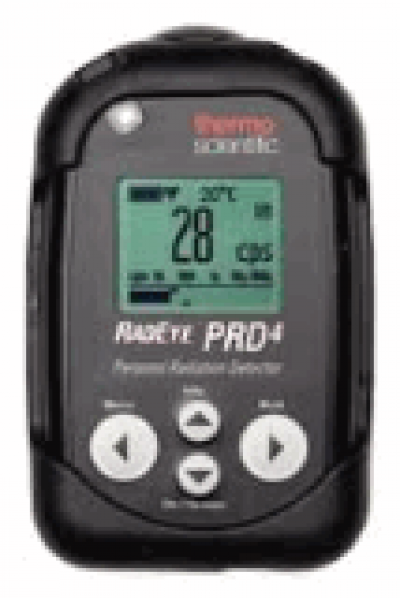
TBox101 Radiation Monitor
TBox101 RadEye PRD-ER4 monitor
- Support dummy battery to provide 3V voltage for device power.
- Easy to change RadEye device mode at Wearable or Standalone.
- Read data from RadEye device through IR interface.
- Supports VGA port output for information display
- Supports data set and get operations on TBox101 via SNMP.
- TBox101 is powered through the USB port.

Hsiung He Silver-Aged Service Co., Ltd.
492
0
Smart Healthcare
《mAST:muscle Auto Strength Training》
mAST: Muscle Auto Strength Training System
Modernizing Tradition: Transforms traditional Squats and Bench Presses into a safety-first, scientifically optimized, and high-efficiency training experience.
Key Product Features
■ Superior Safety & Scientific Precision: Combines high-level safety protocols with data-backed insights for maximized training results.
■ Parameterized Controls: Offers diverse training modes with high-precision resistance control at 1kg increments.
■ Historical Data Analytics: Automatically logs every session, allowing users to track progress through historical data and analyze trends in training effectiveness.
■ AI Virtual Coach: Features automated resistance control paired with human-like audiovisual guidance, interacting with users just like a personal trainer.
■ Space & Cost Efficiency: No need for traditional bulky equipment, reducing procurement costs while creating a sleek, professional, and minimalist environment.
Taiwan Optical Platform
478
0
Smart Home
AI-Integrated Solutions for Smart Disaster Prevention and Site Safety
This project integrates cable TV systems, Civil IoT, and AI video recognition technology to build smart disaster prevention and site safety services. Centered on set-top boxes (STB) and intelligent sensing, the solution focuses on bridging the gap in real-time information and safety protection for elderly and rural populations.
Through its wired network infrastructure, the system developed under this project is capable of delivering real-time disaster prevention information, including earthquakes, typhoons, and heavy rainfall alerts. In addition, AI-based recognition capabilities have been integrated into the system.
Currently, the system has completed event recognition functions such as parcel placement and retrieval detection. It also performs analysis of human movement trajectories and abnormal group behavior detection. In the future, the system will be further expanded to identify dangerous situations such as violent behavior.
Through this project, Taiwan Optical Platform (TOP) demonstrates the potential of integrating cable television networks with AI and IoT technologies to develop a platform for smart disaster prevention and public safety applications.
e-Formula Technologies, INC
2.79k
0
AI / AIoT
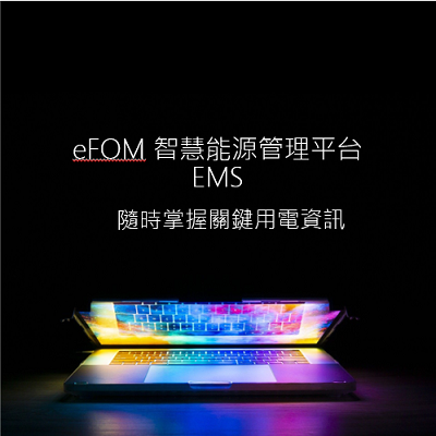
eFOM/EMS
A large number of commercial data are collected through object sensing technology, and the cloud-based visual interface and telecommunication operation surface data are used to assist enterprises to remotely manage the electricity consumption of buildings, manufacturers, business locations, and various branches in real time.
HAMASTAR TECHNOLOGY CO., LTD.
1.66k
0
ESG
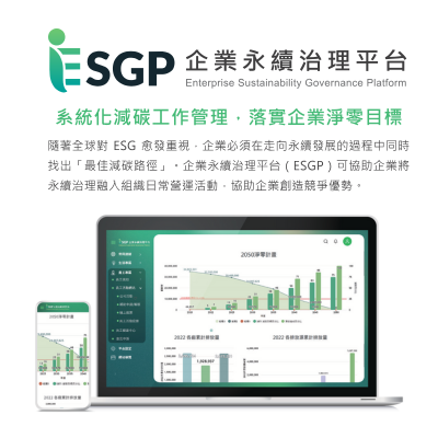
Enterprise Sustainability Governance Platform
ESGP (Enterprise Sustainability Governance Platform): This platform aids businesses in conducting automated carbon footprinting, utilizes AI technology to generate sustainability reports, effectively manage ESG information, and produce various reports tailored for different stakeholders.

Trade-Van Information Services Co.
409
0
AI / AIoT
Trade-Van AI Family
Trade-Van integrates big data governance capabilities with discriminative and generative AI technologies to build an enterprise-grade AI application platform that helps government agencies and enterprises achieve process automation, intelligent decision-making, and optimized risk management.
Through AI-driven document recognition, intelligent agents, and automated customer service systems, organizations can effectively reduce manual operational costs, shorten processing time, and improve decision-making efficiency and service quality.
The AI Family serves as a new engine for intelligent governance, creating a secure, stable, and continuously evolving smart operational environment.
Service Offerings:
readAI – Intelligent image and document recognition
thinkAI – Intelligent agent applications
Smart Customer Service System
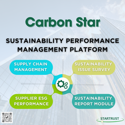
StarTrust System Inc.
2.28k
0
Net Zero Innovation
Sustainability Performance Management Platform
The Sustainability Performance Management Platform assists enterprises in extending their management perspective from direct emissions to the entire value chain, ensuring the precise implementation of supplier sustainability performance management. The system features a comprehensive digital survey and data management platform, covering everything from questionnaire design, distribution, and response collection to multi-level approval and statistical analysis, enabling companies to integrate supply chain data with maximum efficiency.
With flexible template design and year-over-year comparison tools, enterprises can track trends in key issues in real-time. The system supports diverse data entry methods and automated chart generation, while also offering seamless integration with sustainability reporting systems to enable automatic data updates. By leveraging this digital system, companies can establish a highly traceable data management process and significantly strengthen supply chain resilience.
Core System Features:
1. Supplier and Stakeholder Performance Assessment: Digitally collect and audit various ESG indicators.
2. Automated Statistical Analysis and Comparison: Generate real-time visual reports to track annual performance trends.
3. Data Integration and Report Linking: Streamline data aggregation to accelerate the production of sustainability reports.

Climate Change Administration,Ministry of Environment
2.55k
1
Circular Economy
Transforming Textile Waste into Sustainable Recycled Materials
Strong and Wise Materials Technology offers a solution for transforming textile waste into high-value products, promoting low-carbon sustainability and environmental protection. Not only does this solution address the pollution caused by textile waste in urban areas, but it also aids brands and the textile industry in managing over 90% of their textile waste.
Through patented technology, we convert textile waste into high-quality recycled plastic (R-PET) particles for various recyclable plastic products. Additionally, we produce environmentally friendly green building materials (EF Wood) suitable for different environments, resolving issues associated with solid wood and plastic wood while creating a variety of wood-like furniture. All our products are 100% recyclable.
Strong and Wise provides truly sustainable and circular solutions, generating renewed value from textile waste.

意藍資訊股份有限公司
2.56k
3
AI / AIoT
OpView
OpView is the largest Social Listening platform in Taiwan, offering a comprehensive data analysis tool that enables real-time public opinion monitoring. Leveraging cutting-edge AI-powered Semantic Analysis and Search Engine technologies, OpView delves into a vast pool of 10 billion Chinese characters collected daily to extract meaningful social insights.
Our platform excels at capturing trends and community dynamics, delivering enterprises with valuable information to stay ahead of the curve.

SYSCOM computer engineering Co.
3.97k
1
E-Office
SONOBA COMET
SONOBA COMET is a paperless conference system using tablet computers. Simple, no complicated operation or preparation required. Convenient, one-person operation, all participants can be expressed simultaneously. Information security, delete the information after the meeting.
SONOBA COMET” is a product that has been positively received and implemented by a wide range of customers in different industries and business categories, such as banks and brokerages, IT companies and music-related companies, and public institutions like universities and hospitals.
As a communication tool, it is performing well not only in meetings but also in various other scenes such as presentations for operating activities, training and seminars, and telemedicine.
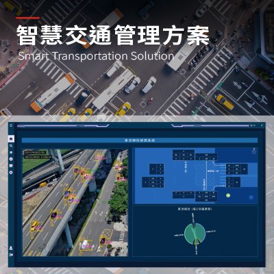
Ability Intelligent Corporation
899
0
Smart Transportation
Smart Transportation Solution
Detect Traffic Anomalies Quickly. Minimize Risk.
Traffic risks arise suddenly and unpredictably, challenging traditional monitoring systems to detect them in real time. With advanced AI-powered video analytics and intelligent event detection, Ability Intelligent delivers real-time, automated identification of traffic anomalies—capabilities that exceed traditional monitoring—by instantly flagging vehicle stoppages, wrong-way driving, congestion, pedestrian intrusions, and other unexpected incidents, all accompanied by visual alerts for actionable intervention.
The system proactively identifies abnormal conditions and potential risks, helping traffic authorities shorten response times, prevent incident escalation, and strengthen overall road and public space safety. Ability Intelligent empowers safer, resilient urban transportation with proactive technology.
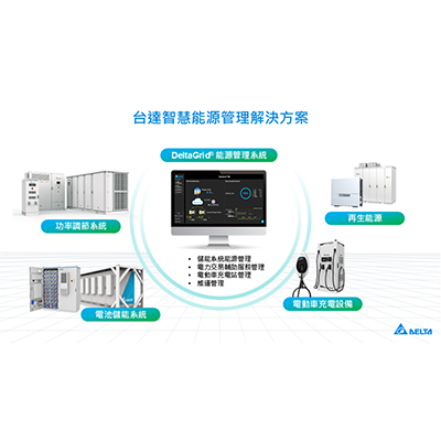
Delta
2.26k
0
Smart Grid
Delta Smart Energy Management Solutions
DeltaGrid® low-carbon emission energy solution focuses on the four major perspectives of energy creation, energy storage, energy control, and energy saving. It integrates solar energy, energy storage, EV chargers, energy management, as well as energy saving software and hardware products to provide a practical transformation solution that helps strengthen grid resilience, optimize energy dispatching, enhance renewable energy utilization, and achieve cost and energy saving, carbon emission reduction, and net zero sustainability goals. The solution is for four major areas, including power plants, industrial and commercial factories, electric vehicle charging stations, and community residences, so that renewable energy can be stably connected to the grid, stabilize the electricity consumption of industrial and commercial factories, and improve the operating efficiency of charging stations.
 、Firefox
  、Edge
、Edge  瀏覽器!
瀏覽器!