solution(180)

Far EasTone Telecommunications Co., Ltd.
469
0
Smart Healthcare
Health+ APP
FarEasTone launched Taiwan’s first “5G Telemedicine” service, using 5G technology to build an instant and convenient telemedicine platform that brings medical resources to rural and outlying areas. The service has also been expanded for use in emergency rescue, Video Consultation, and long-term care applications.
The platform is further integrated with the FarEasTone Health+ App, providing the public with easy access to daily health management, health/care consultations, medical appointments, and video consultations—all in one place.
With the app in hand, your personal health management becomes easier than ever!
中嘉寬頻股份有限公司
409
0
Smart Transportation
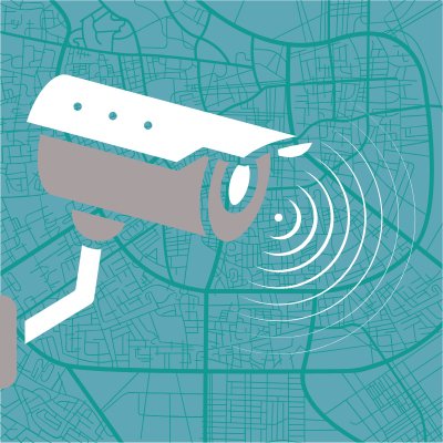
Public, city surveillance and fixed-line circuit solutions
We offer comprehensive surveillance system integration services to meet the needs of public domains and urban governance. This includes professional monitor installation, high-capacity video storage planning, and VPN circuit transmission services to ensure secure data transfer, establishing a reliable digital foundation for urban security.
StarTrust System Inc.
2.40k
1
Net Zero Innovation
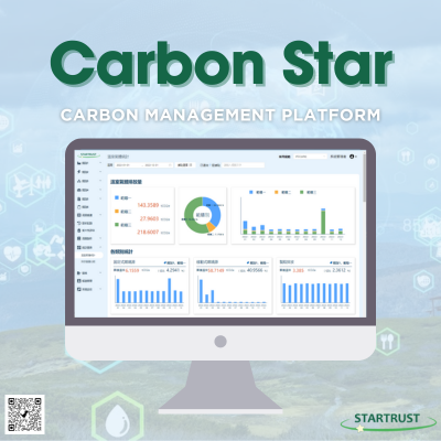
Carbon Star - Carbon Management Platform
Carbon Star is a specialized greenhouse gas (GHG) inventory management platform developed by StarTrust Systems, offering enterprises extensive carbon management capabilities.
The platform encompasses organizational greenhouse gas inventories (ISO 14064-1) and product carbon footprint inventories (ISO14067), featuring the most extensive functional modules to enable enterprises to effectively gather carbon emissions data throughout their operations.
1. The platform is equipped with calculation benchmarks for carbon emissions and the latest factor data, facilitating enterprises in promptly collecting and computing data.
2. It integrates comprehensive management functions, including approval workflows and reminders, to assist various departments within enterprises in effectively managing greenhouse gas emissions.
3. Departmental access is segregated to ensure confidentiality across departments, allowing cross-departmental retrieval and referencing of only designated data. This measure guarantees the confidentiality of information from both manufacturing facilities and product domains.
4. Carbon Star automatically generates reports and emission inventories swiftly, streamlining enterprise management and verification processes.
5. Data analysis results are presented through a dashboard interface, empowering enterprises to compare and analyze data efficiently.

SYSCOM computer engineering Co.
3.91k
1
E-Office
SONOBA COMET
SONOBA COMET is a paperless conference system using tablet computers. Simple, no complicated operation or preparation required. Convenient, one-person operation, all participants can be expressed simultaneously. Information security, delete the information after the meeting.
SONOBA COMET” is a product that has been positively received and implemented by a wide range of customers in different industries and business categories, such as banks and brokerages, IT companies and music-related companies, and public institutions like universities and hospitals.
As a communication tool, it is performing well not only in meetings but also in various other scenes such as presentations for operating activities, training and seminars, and telemedicine.

Fashion Intelligence Co.,Ltd.
5.19k
0
Smart Transportation
Intelligent Positioning System
Intelligent Positioning System can remotely track the paths, remotely set the access authority, and provide the access alarm and SOS alarm based on configured location Bluetooth sensors. There are three applications:
[Guardian Wristband]
Authority can know whether home quarantine people are at home. Through the beacon wristband connects with receiver. If home quarantine people are leaving home, the system will send notification to the authority.
[Indoor Navigation]
Locate users’ position via Bluetooth and precede indoor navigation to let users know their position and find the way in building. This service is applicable to large areas such as airports, stations, department stores, etc.
[Intelligence on People Seeking]
With smart positioning wristband, users can instantly know current location of their children or parents via App. It could avoid the common problem of missing family.
Nantou County Goverment
362
0
Smart Governance
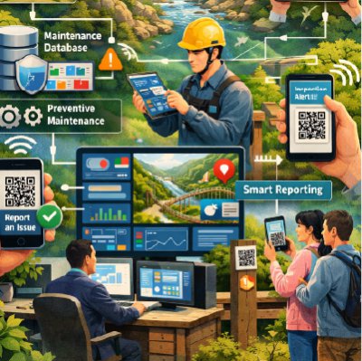
Smart Scenic Area Management System
To enhance facility management efficiency and visitor service quality in Nantou County’s scenic areas, the Nantou County Scenic Area Administration Office is implementing a Smart Management System. The system applies digital technologies to strengthen operations, safety management, and data-driven governance.
It integrates maintenance and inspection records for key facilities such as trails and suspension bridges, establishing a centralized database. Through data analysis, authorities can monitor facility conditions, identify maintenance needs, and implement preventive maintenance strategies, reducing costs and improving operational stability.
CCTV and smart sensors are gradually deployed in high-risk areas to enable real-time monitoring and anomaly alerts. During extreme events such as typhoons or earthquakes, managers can quickly assess infrastructure safety, improve emergency response efficiency, and reduce manual inspection workload.
A QR Code-based smart reporting function allows visitors to instantly report facility issues. Reports are automatically recorded and assigned for follow-up, accelerating response time and enhancing visitor safety and service experience.
Through smart management and data-driven decision-making, Nantou County is building a safer, more efficient, and sustainable scenic area management model, supporting smart tourism and long-term development.
Hon Hai Precision Industry Co.,Ltd.
2.10k
0
Smart Transportation
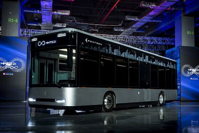
Low Entry Electric bus- Model T
The technical solution of Foxtron Electric Bus combines domestic and international resources, each contributing its strengths:
1. It adopts Foxtron's self-developed VCU software, integrates and develops the EEA architecture for electric buses, and utilizes motors, batteries, and chassis suspension systems from international major manufacturers. In collaboration with domestic manufacturers, Foxtron designs and develops dedicated low-floor bus frames for chassis cooperation.
2. In the product design of electric buses, Foxtron identifies pain points in traditional buses and improves upon them. For example, traditional buses often have issues with rollover protection and numerous blind spots, as well as differential wheel rotation caused by wheelbase, leading to frequent traffic accidents due to visibility problems. To address these issues, Foxtron employs Computer-Aided Engineering (CAE) and NVH (Noise, Vibration, and Harshness) analysis to verify the design of various systems and components. This ensures the overall strength of the vehicle body and chassis, enhances passenger safety, and incorporates features such as panoramic image display and an electronic wide-angle rearview mirror with a blind spot detection system to solve driver blind spot issues. Additionally, to alert pedestrians and other road users to the risk of differential wheel rotation, Model T projects prominent light beams onto the ground during turns, marking the danger zone.
Ability Intelligent Corporation
840
0
Smart Transportation
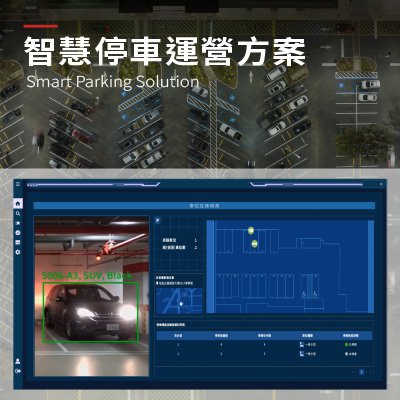
Smart Parking Solution
The innovative parking operations solution integrates AI-based Automatic Number Plate Recognition (ANPR), sensing devices, IoT infrastructure, and a cloud management platform. By streamlining parking management, reducing manual intervention, and providing actionable insights through real-time data, this solution helps parking operators maximize space utilization and enhance customer satisfaction with a transparent, data-driven, brilliant parking service.
The system provides real-time visibility into vehicle entry and exit, space occupancy, and on-site traffic flow. It supports ticketless access and license plate–based payment. It also offers real-time parking guidance and multiple payment options. These features reduce labour costs and enhance the user parking experience. A centralized management platform and operational data analytics give operators insights into traffic patterns, space turnover, and revenue performance. This enables informed decisions on pricing strategies and space allocation. As a result, operators can achieve efficient, sustainable smart parking operations.
Wave-In Communication
3.01k
0
5G Telecommunication
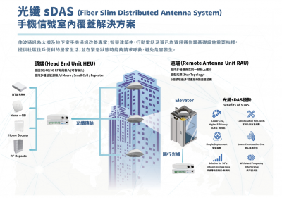
Wave-In sDAS Indoor Coverage & MR Solution
With our fiber sDAS, Wave-In effectively reduce mobile signal dead spots caused by insufficient base station coverage, buildings or electromagnetic signal interference. Due to the pandemic, Taiwanese Engineers weren’t able to assist with on-site installation and coverage testing, to solve this problem and improve efficiency, Wave-In utilized Mixed Reality for collaboration and remote assistance.
Taiwan Association of Disaster Prevention Industry
406
0
Smart Governance
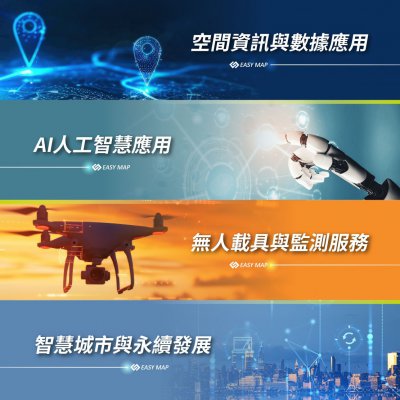
Geospatial Information and Data Applications and Unmanned Systems and Monitoring Services
At EasyMap Digital Technology Inc., we focus on four core technologies: Geospatial information and data applications, artificial intelligence, unmanned systems and monitoring services, and sustainable smart city. These technologies enable us to deliver fully integrated, cross-disciplinary smart solutions.
Our services encompass eight application areas: smart agriculture, digital real estate services, cloud-based intelligent monitoring systems, smart IoT solutions, sustainable Smart city, collaborative operations for the National Maps, intelligent tax solutions, and UAV mapping service.
By deeply integrating GIS, AI, and drone technologies, we help governments and enterprises enhance decision-making efficiency, strengthen operational management, and drive innovation through technology—enabling a smarter future that balances performance with long-term sustainability.

Trade-Van Information Services Co.
347
0
AI / AIoT
Trade-Van EZESG
EZESG by Trade-Van Information Services Co. helps enterprises systematically complete organizational greenhouse gas (GHG) inventories in accordance with ISO 14064-1, strengthening carbon management and enhancing transparency in information disclosure.
The system enables rapid establishment of an emissions source database by integrating data from energy consumption, raw materials, and operational activities. Through AI-powered OCR, it automatically identifies information from utility bills such as fuel, water, and electricity. It also incorporates Google Maps mileage calculations and taxi carbon emission models to estimate emissions from transportation activities.
With built-in intelligent calculation models, the platform automatically consolidates Scope 1, Scope 2, and Scope 3 emissions data, reducing manual errors while improving data consistency and reliability.
The system also supports one-click generation of GHG inventory reports and supporting documentation, simplifying procedures and shortening preparation time. Through digitalization and intelligent management, it helps enterprises respond to international regulatory requirements and steadily progress toward net-zero emissions and sustainability goals.

中嘉寬頻股份有限公司
418
0
Smart Security
Smart Community Integration Solution
We are committed to creating a convenient and safe smart community living experience. Our services integrate the Wofu Community APP for residents, the installation of surveillance cameras in public areas of the community, and advanced lane management and license plate recognition systems to achieve technologically advanced community access and security management.
 、Firefox
  、Edge
、Edge  瀏覽器!
瀏覽器!