solution(180)
意藍資訊股份有限公司
2.45k
3
AI / AIoT
OpView
OpView is the largest Social Listening platform in Taiwan, offering a comprehensive data analysis tool that enables real-time public opinion monitoring. Leveraging cutting-edge AI-powered Semantic Analysis and Search Engine technologies, OpView delves into a vast pool of 10 billion Chinese characters collected daily to extract meaningful social insights.
Our platform excels at capturing trends and community dynamics, delivering enterprises with valuable information to stay ahead of the curve.
Kaohsiung Medical University
399
0
Smart Healthcare
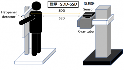
Intelligent X-ray Imaging System
Prof. Ming-Chung Chou’s Team – Intelligent X-ray Imaging System
Traditional X-ray imaging depends on experienced radiographers to balance image quality and
radiation dose. Automatic exposure control may misjudge patients with poor positioning or metallic
implants, increasing radiation by about 20%. This study develops an AI-based X-ray imaging system
with non-contact body thickness measurement. By integrating patient height and weight, the system
automatically determines optimal exposure parameters, ensuring stable image quality while reducing
unnecessary radiation and cancer risk.
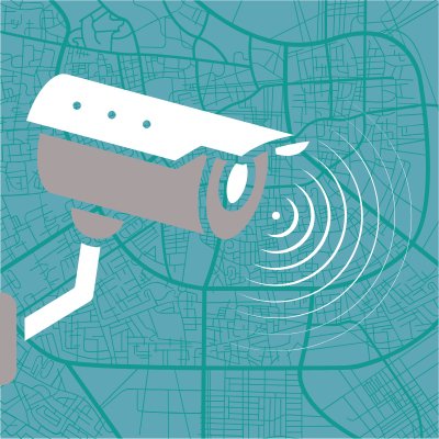
Taiwan Association of Disaster Prevention Industry
353
0
Smart Governance
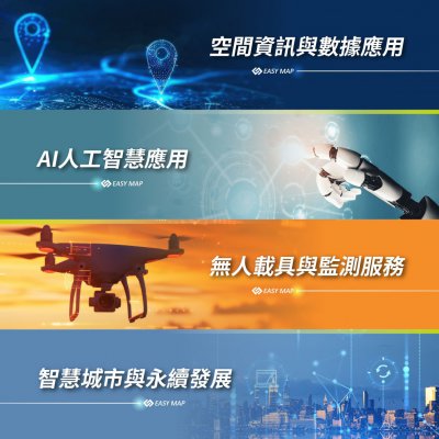
Geospatial Information and Data Applications and Unmanned Systems and Monitoring Services
At EasyMap Digital Technology Inc., we focus on four core technologies: Geospatial information and data applications, artificial intelligence, unmanned systems and monitoring services, and sustainable smart city. These technologies enable us to deliver fully integrated, cross-disciplinary smart solutions.
Our services encompass eight application areas: smart agriculture, digital real estate services, cloud-based intelligent monitoring systems, smart IoT solutions, sustainable Smart city, collaborative operations for the National Maps, intelligent tax solutions, and UAV mapping service.
By deeply integrating GIS, AI, and drone technologies, we help governments and enterprises enhance decision-making efficiency, strengthen operational management, and drive innovation through technology—enabling a smarter future that balances performance with long-term sustainability.

Z-COM, Inc.
1.91k
0
Smart Transportation
Smart Transportation Railway Application
EdgeLink-X is an AI-driven heterogeneous edge-network platform built to provide resilient, low-latency connectivity for intelligent transportation and railway environments. The system forms a multi-layer architecture that unifies field communications, sensing, video capture, and edge analytics into a reliable and adaptive communication framework.
At the field level, IP110H and IP503H Lite IP radios deliver instant voice communication and group coordination for frontline personnel. Sensors and cameras are connected through the AG260 AIoT Gateway, while the AS710 Wi-Fi 7 indoor access point provides high-quality Wi-Fi coverage in stations, platforms, and passenger areas to enhance traveler connectivity.
Long-range, time-synchronized backhaul is supported by the SP250 Series, ensuring stable, high-throughput wireless links across trackside and outdoor environments. At the core, the zMEC edge-computing platform performs real-time AI video analytics, abnormal-event detection, and rapid data distribution to minimize latency and support mission-critical responses.
By integrating Wi-Fi, LTE, 5G, PTP wireless backhaul, and AIoT devices into a single cohesive system, EdgeLink-X enables applications such as slope monitoring, intersection intrusion detection, pantograph spark/wear monitoring, and onboard operational visibility—forming a robust foundation for next-generation safe and intelligent mobility.

Qualcomm Incorporated
362
0
AI / AIoT
Qualcomm® Insight Platform
The Qualcomm Insight Platform (QIP) delivers an end-to-end video intelligence solution powered by Qualcomm Technologies’ industry-leading on-device AI. It provides centralized video intelligence management across diverse sources and leverages real-time edge AI analytics to reduce latency and accelerate decision-making. A built-in multimodal AI engine integrates image, speech, and text capabilities while optimizing performance, security, and total cost of ownership (TCO) for stable and highly scalable deployments.
Paired with Innodisk’s edge AI box and IP cameras, QIP enables high-efficiency real-time edge analytics, supporting multimodal AI and natural language search while integrating seamlessly with existing infrastructure. It enhances worker safety, optimizes logistics processes, and strengthens restricted area management, helping organizations improve operational efficiency and risk control. The platform transforms surveillance into actionable security and operational insights with built-in privacy and compliance while ensuring data privacy and regulatory compliance. It is suitable for smart cities, manufacturing, energy and utilities, warehousing and logistics, retail and commercial spaces, healthcare and education, transportation, as well as enterprise and building management scenarios.
* Qualcomm branded products are products of Qualcomm Technologies, Inc. and/or its subsidiaries. Qualcomm is a trademark or registered trademark of Qualcomm Incorporated.
SOYAL Technology Co., Ltd
339
0
Smart Energy Saving
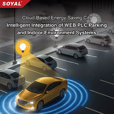
Cloud-Based Energy-Saving City | Intelligent Integration of WEB PLC Parking and Indoor Environment Systems
SOYAL Smart Parking Lighting System integrates RFID and infrared sensing to automatically pre‑light target spaces upon vehicle entry, while dynamic “lights follow the car, off when it passes” guidance ensures safety, efficiency, and energy savings for low‑carbon smart parking. The WEB PLC Air‑Conditioning Control System uses DI sensors to detect occupancy and temperature differences, adjusting indoor climate on demand to optimize building energy performance and support carbon‑reduction goals. The WEB PLC Office Lighting Control System combines card recognition with infrared sensing to maintain uninterrupted lighting when staff are present, then provides a five‑minute buffer before shutdown after work hours, with secondary detection to confirm departure. This precise energy management maximizes the value of every kilowatt. Together, these three systems highlight the advantages of smart building automation—delivering comfort, safety, and sustainability.
中嘉寬頻股份有限公司
362
0
Smart Transportation
Public, city surveillance and fixed-line circuit solutions
We offer comprehensive surveillance system integration services to meet the needs of public domains and urban governance. This includes professional monitor installation, high-capacity video storage planning, and VPN circuit transmission services to ensure secure data transfer, establishing a reliable digital foundation for urban security.
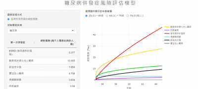
Kaohsiung Medical University
399
0
Smart Healthcare
A Prediction Model for Type 2 Diabetes Complications
Prof. Ming-Yen Lin’s Team – A Prediction Model for Type 2 Diabetes Complications
Our research group develops a decision-support prediction model for type 2 diabetes
complications using data from over 163,000 Taiwanese patients. Integrating age, HbA1c,
and other dynamic factors, the model estimates long-term risks of major complications and
mortality, visualizes future trends, and supports personalized care planning to improve
disease management and outcomes.
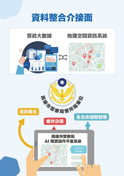
Kaohsiung City Government
3.16k
0
Smart Security
3D street violence early warning, AI intelligence collection and integration platform.
Criminal and street violence cases will affect and cause panic to citizens. In order to diminish street violence cases, reducing the time to solve these cases, protecting citizens’ lives and properties, and allow citizens to live without fear, the Kaohsiung City Police Department (KCPD) built the “3D Street Violence Early Warning, AI Intelligence Collection and Integration Platform” (hereinafter called “the Platform”). The platform utilizes the Internet of Things (IoT) to combine AI image recognition and sound sensing technologies for cross-domain big data analyses.
KCPD established cross-platform data interfacing and integration, mainly through “data integration” and “network analyses” to collect with the municipal government’s transportation bureaus and social bureaus; and import existing data from the KCPD data platforms. The Platform will, through web service API, (a) retrieve data built by information systems, (b) conduct big data analysis, aggregate applicable intelligence data and present it in the form of dynamic information, (c) Integrate all information and display it as maps and topologies, improve case handling efficiency. According to KCPD employees’ query, they can adjust factor weights and relationships. Analyze the results based on rational mathematical models and professional case-handling concepts, so that intelligence analysis goes beyond the limitations of platform developers and allows criminal police to maximize their capabilities.
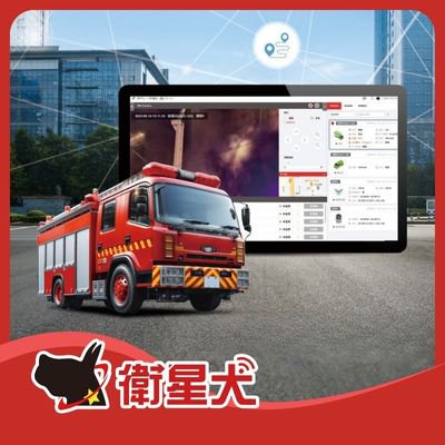
EUPFIN Technology Co.
649
0
Smart Transportation
Fire Emergency Response & Video Integration Platform
Eup has developed a comprehensive video integration platform tailored for fire and emergency rescue operations.
By connecting vehicle GPS, 360-degree cameras, body-worn cameras, and drone footage, command centers gain real-time, multi-angle situational awareness. This significantly enhances decision-making accuracy and frontline personnel safety—using technology to protect those at the very front line of emergency response.
Unified Information Platform: Integrates ground-level and aerial perspectives to deliver complete emergency intelligence.
Real-Time Command & Dispatch: Live video streaming ensures commanders stay fully informed of frontline conditions.
Enhanced Responder Safety: Real-time monitoring of firefighter environments to predict risks and provide timely support.
Cloud Video Backup: Secure cloud storage for rescue footage and operational records.
EUPFIN Technology Co.
3.02k
3
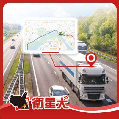
Smart Transportation
Smart Transportation Management Solution
"EUP Fleet Management System" can easily manage the core needs of vehicle dynamics, task progress, emergency response, and utilize AI to analyze driving behavior, fuel consumption, and effectively control costs. In addition, EUP provides comprehensive safety driving checks, tracks driver driving habits and physiological monitoring, significantly improving driving safety, and assisting companies in building a safe, efficient, and low-carbon transportation fleet.
Ability Intelligent Corporation
751
0
Smart Security
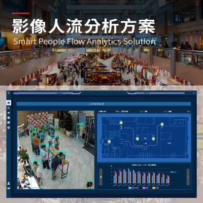
Smart People Flow Analytics Solution
Live crowd movement information is crucial in busy public spaces. Manual checks and basic sensors often lack accuracy and fail to keep up with real-time changes. The People Counting System uses AI video analytics and multi-sensor fusion. It delivers accurate, real-time crowd data. The system automatically counts people, tracks direction, monitors density, and provides instant alerts and reports. Deep learning ensures accuracy in low-light or crowded conditions. Multi-target tracking prevents double-counting.
Edge computing and cloud-based management enable on-site analysis and long-term monitoring. Integrating cameras, infrared, Wi-Fi, and Bluetooth data improves detection and increases coverage. The system generates real-time heat maps, flow analyses, and historical records. These support layout optimization, entry regulation, evacuation planning, and efficiency. The system serves malls, transit hubs, campuses, parks, and public buildings. It is vital for smart cities. It replaces manual counting with intelligent management for better safety, responsiveness, and adaptability.
 、Firefox
  、Edge
、Edge  瀏覽器!
瀏覽器!