solution(180)
SYSCOM computer engineering Co.
4.21k
0
Smart Security
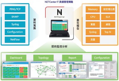
NETCenter IT Infrastructure Management Center
NETCenter is an integration and management application, which provides various management functions, like: fault, configuration, accounting, performance and security. All connections and network equipment are under control, you won’t disconnect any network connection, then figure out the problem.
Our innovative features are:
1. No need to install a front-end application. No add-ons are need. Remotely manage via Web Browser.
2. Provides Auto-Discover and Topology and automatically generates an L2 Topology.
3. Supported Protocols: SNMP v2C/v3, Telnet, FTP, SMTP and ICMP. NETCenter manages all equipment that supports CLI (Command Line Interface).
4. Provides professional customized services to satisfy enterprise IT infrastructure management.
Smooth and stable networks are affected by the rate of information exchange, also it’s an important symbol of an enterprise. Almost all enterprises use multiple vendor's equipment. In conclusion, NETCenter can reduce TCO and increase ROI.
Taiwan Association of Disaster Prevention Industry
406
0
Smart Governance
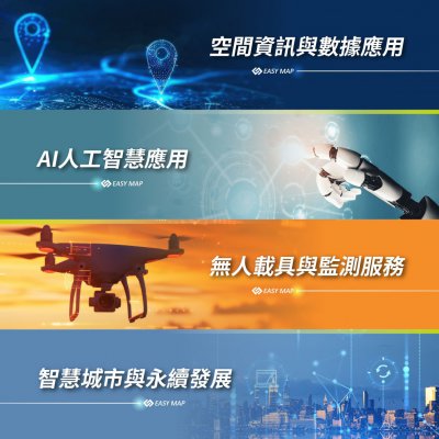
Geospatial Information and Data Applications and Unmanned Systems and Monitoring Services
At EasyMap Digital Technology Inc., we focus on four core technologies: Geospatial information and data applications, artificial intelligence, unmanned systems and monitoring services, and sustainable smart city. These technologies enable us to deliver fully integrated, cross-disciplinary smart solutions.
Our services encompass eight application areas: smart agriculture, digital real estate services, cloud-based intelligent monitoring systems, smart IoT solutions, sustainable Smart city, collaborative operations for the National Maps, intelligent tax solutions, and UAV mapping service.
By deeply integrating GIS, AI, and drone technologies, we help governments and enterprises enhance decision-making efficiency, strengthen operational management, and drive innovation through technology—enabling a smarter future that balances performance with long-term sustainability.

Far EasTone Telecommunications Co., Ltd.
914
0
Energy Management
Public Building Net-Zero and Disaster-Resilience Energy Storage Program
Far EasTone Telecommunications (FET) is committed to corporate sustainability and net-zero transformation. By integrating telecommunications with digital technologies, FET helps industries and society reduce carbon emissions.
In the public building sector, FET is developing integrated solutions for “Net-Zero and Disaster-Resilient Energy Storage.” Combining net-zero strategies with Energy Management Systems (EMS), FET deploys renewable energy, energy storage, and smart energy-saving mechanisms. This approach balances carbon reduction with power resilience, supporting the public sector in enhancing sustainability and disaster preparedness.
A key achievement is the National Taiwan Ocean University (NTOU) Gymnasium project, where FET implemented an advanced energy management platform integrating power monitoring, smart HVAC control, and renewable energy with storage systems. These efforts improved energy efficiency, provided a model for transitioning public buildings to net-zero, and earned the client Level 1+ Green Building certification.
Looking ahead, FET will continue investing in net-zero buildings, energy storage, and resilient energy systems. Through collaboration with government, academia, and industry partners, FET aims to accelerate Taiwan’s progress toward sustainable development goals, advancing both net-zero emissions and disaster prevention.
AIRA Corporation
2.57k
0
AI / AIoT
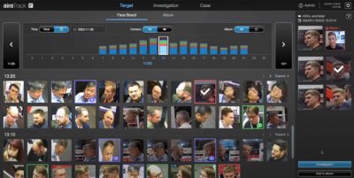
airaTrack- Facial Tracking Solution
airaTrack is a comprehensive personnel tracking system that utilizes AI algorithms developed by our team to extract features from both the "face and figure." It generates unique biometric IDs with a recognition accuracy of up to 99%, all without the need for registering facial data, addressing privacy concerns. Capable of cross-camera searches and matching 10,000 faces per second, it significantly enhances the efficiency of traditional manual matching processes and increases search efficiency and accuracy by 97% enabling automatic path tracking of personnel in the field. The system also generates investigation reports for evidential preservation.
Taiwan AI Cloud Corporation
1.75k
0
AI / AIoT
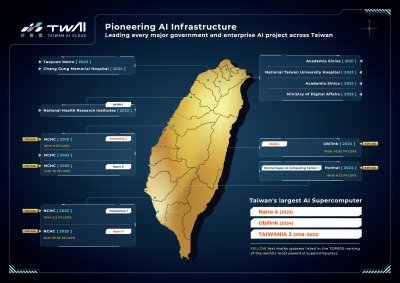
AI Compute Foundry
Taiwan AI Cloud AI Compute Foundry solution provides one-stop AI infrastructure services.
Assist governments, enterprises, and the global GPU market in driving the development of sovereign AI.
Empower enterprises to build customized AI compute centers with their own AI infrastructure, data governance, and model operation environments.
We provide complete AIHPC deployment, integration, and maintenance services, supporting private, public, and hybrid cloud architectures.
TECO
3.11k
1
Smart Disease Control and Prevention
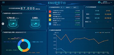
ESG Ready : CNm (Carbon Neutral management)
Capable of helping customers complete ISO-14064 greenhouse gas inventory rapidly and correctly, the platform offers boasts provision of real-time greenhouse gas emission data, production of lists and tables, and carbon emission forecast, , thereby assisting enterprises in planning carbon-abatement investments, attaining emission reduction according to timeline, and optimizing emission management flow.
Kaohsiung Medical University
445
0
Smart Healthcare
A Prediction Model for Type 2 Diabetes Complications
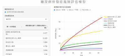
Prof. Ming-Yen Lin’s Team – A Prediction Model for Type 2 Diabetes Complications
Our research group develops a decision-support prediction model for type 2 diabetes
complications using data from over 163,000 Taiwanese patients. Integrating age, HbA1c,
and other dynamic factors, the model estimates long-term risks of major complications and
mortality, visualizes future trends, and supports personalized care planning to improve
disease management and outcomes.

HI-POWER SOLUTION CO., LTD.
2.33k
0
Smart Transportation
Dual-Lens Thermal & Full-Color Camera
Feature
•Automatic Gain Control (AGC).
•Backlight Compensation.
•Automatic White Balance.
•Wide Dynamic Range (WDR) function with 120dB at 30 FPS.
•Night noise suppression function.
•Nighttime shooting with automatic aperture adjustment.
•Stable image quality during low-light shooting at night under stable external light conditions, ensuring no flicker or color rolling, and clear nighttime images.
Specifications
•Uses a CMOS 1/3” Image Sensor.
•MAX Resolutions:2MP (1920×1080 pixels),D1 (640x480 pixels)
•Maximum Frame Rate:30 FPS @1920×1080,30 FPS @640x480
•Focal Length:2MP lens : 2.8-12mm±5%,D1 lens : Fixed
•Minimum Illumination:Color: Below 0.06 Lux,Black:Below 0.02 Lux.
HI-POWER SOLUTION CO., LTD.
2.50k
2
Smart Transportation
Intelligent Transportation Data Collection (ITS)
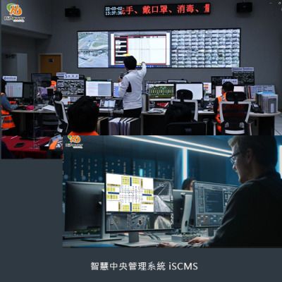
ITS traffic data collection has solved the laborious and time-consuming task of manually calculating traffic flow in the past. It aims to achieve the goals of smoother road conditions and reduced accidents through intelligent traffic diagnosis. By utilizing intelligent transportation systems, the system automatically tracks vehicles, identifies vehicle types, predicts trajectories, and transforms the data into useful information. This assists in real-time interpretation and improvement of traffic engineering. This system is particularly crucial in Taiwan, where over 60% of traffic accidents occur at intersections. Through big data analysis, identifying issues and formulating solutions is possible, thereby lowering accident risks. This approach proves more effective than simple advocacy and alerts.
Nantou County Goverment
365
0
Smart Governance
Smart Scenic Area Management System
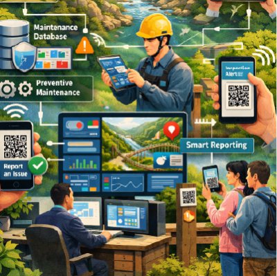
To enhance facility management efficiency and visitor service quality in Nantou County’s scenic areas, the Nantou County Scenic Area Administration Office is implementing a Smart Management System. The system applies digital technologies to strengthen operations, safety management, and data-driven governance.
It integrates maintenance and inspection records for key facilities such as trails and suspension bridges, establishing a centralized database. Through data analysis, authorities can monitor facility conditions, identify maintenance needs, and implement preventive maintenance strategies, reducing costs and improving operational stability.
CCTV and smart sensors are gradually deployed in high-risk areas to enable real-time monitoring and anomaly alerts. During extreme events such as typhoons or earthquakes, managers can quickly assess infrastructure safety, improve emergency response efficiency, and reduce manual inspection workload.
A QR Code-based smart reporting function allows visitors to instantly report facility issues. Reports are automatically recorded and assigned for follow-up, accelerating response time and enhancing visitor safety and service experience.
Through smart management and data-driven decision-making, Nantou County is building a safer, more efficient, and sustainable scenic area management model, supporting smart tourism and long-term development.
EUPFIN Technology Co.
701
0
Smart Transportation
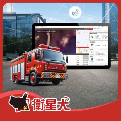
Fire Emergency Response & Video Integration Platform
Eup has developed a comprehensive video integration platform tailored for fire and emergency rescue operations.
By connecting vehicle GPS, 360-degree cameras, body-worn cameras, and drone footage, command centers gain real-time, multi-angle situational awareness. This significantly enhances decision-making accuracy and frontline personnel safety—using technology to protect those at the very front line of emergency response.
Unified Information Platform: Integrates ground-level and aerial perspectives to deliver complete emergency intelligence.
Real-Time Command & Dispatch: Live video streaming ensures commanders stay fully informed of frontline conditions.
Enhanced Responder Safety: Real-time monitoring of firefighter environments to predict risks and provide timely support.
Cloud Video Backup: Secure cloud storage for rescue footage and operational records.
Join It Sustainable Tech.Co.,Ltd.
379
0
Solar Energy
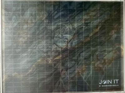
Color-painted Solar Panel
Join It Sustainable turns building façades into power-generating surfaces with a circular, eco-friendly painted PV coating—blending renewable energy with architecture and branding. The coating is anti-soiling, scratch-resistant, rain self-cleaning and designed to reduce glare, while keeping PV performance. Applicable to façades, balconies, carports, shading elements and signage to unlock more renewable area for retrofit and net-zero buildings.
Taiwan’s first public demonstration of a color-painted PV façade: showcased at the Architecture and Building Research Institute (ABRI,MOI), Ministry of the Interior. Phase I & II results prove façade PV can be safely and stably deployed on existing public buildings—turning decorative cladding into a consistent, power-generating building envelope.
 、Firefox
  、Edge
、Edge  瀏覽器!
瀏覽器!