solution(180)
HAMASTAR TECHNOLOGY CO., LTD.
1.49k
0
Smart Manufacturing
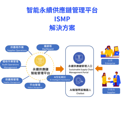
Intelligent Supply Chain Management Platform
Powered by AI, this platform provides businesses with compliance management, risk intelligence analysis, and data-driven sustainable supply chain resilience, enabling them to effectively manage their supply chains.

PYRAMIUS SOLUTION CO., LTD.
175
0
Smart Building
Jobdone Construction & Installation: Professional contractor for "Low-Carbon Production" Digital Centers
Jobdone's "Construction & Manufacturing" module is specifically designed for contractors specializing in system furniture, precast engineering, steel structures, and fencing. Addressing the characteristics of **"in-factory processing and on-site assembly"**, it provides a powerful digital dispatch center to coordinate personnel, equipment, materials, and vehicle dispatch. Through digital work order management, businesses can precisely control every step from shipment to each stage of construction, significantly improving delivery efficiency. Regarding net-zero solutions, this module reduces carbon emissions from redundant vehicle dispatches through precise resource scheduling and replaces paper processing and acceptance forms with digital forms. Combined with phased completion inspections, it effectively reduces material waste caused by construction errors, assisting subcontractors in practicing a circular economy from processing to assembly, and achieving the carbon reduction transformation goals in smart city construction.
HI-POWER SOLUTION CO., LTD.
2.28k
2
Smart Transportation
Intelligent Transportation Data Collection (ITS)
ITS traffic data collection has solved the laborious and time-consuming task of manually calculating traffic flow in the past. It aims to achieve the goals of smoother road conditions and reduced accidents through intelligent traffic diagnosis. By utilizing intelligent transportation systems, the system automatically tracks vehicles, identifies vehicle types, predicts trajectories, and transforms the data into useful information. This assists in real-time interpretation and improvement of traffic engineering. This system is particularly crucial in Taiwan, where over 60% of traffic accidents occur at intersections. Through big data analysis, identifying issues and formulating solutions is possible, thereby lowering accident risks. This approach proves more effective than simple advocacy and alerts.
SynaiQ CO., LTD
109
0
AI / AIoT
Smart City Online – Customized AI Solutions & System Integration
This solution provides customized AI model development and system integration services for governments and enterprises with existing systems and data. SynaiQ delivers end-to-end support, including consulting, LLM design, deployment, and long-term maintenance. The modular and scalable architecture reduces barriers to AI adoption while enabling organizations to build sustainable, flexible, and future-ready intelligent systems.

Climate Change Administration,Ministry of Environment
2.13k
0
Circular Economy
UKL ENTERPRISE CO., LTD.
PALF is committed to developing eco-friendly textile products by using recyclable, zero-carbon emission agricultural waste "Pineapple Leaf" to establish the first localized sustainable yarn and fabric pilot production line in Taiwan. We promote the recycling of waste materials to create a more environmentally friendly, sustainable textile and fashion industry.
ASUS MAAS CORPORATION
143
0
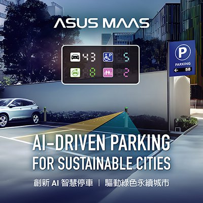
Smart Transportation
AI-DRIVEN PARKING FOR SUSTAINABLE CITIES
In the evolving architecture of smart cities, AI-powered smart parking systems have transformed from standalone parking management tools into critical nodes within intelligent urban operations. By integrating AIoT sensing, image recognition, and cloud platforms, the system enables real-time parking occupancy monitoring, license plate recognition, and traffic flow prediction, enhancing traffic efficiency and optimizing road resource allocation.
It connects people, vehicles, facilities, and payment processes into a unified ecosystem, streamlining circulation and improving user experience. By incorporating EV charging infrastructure, the platform supports green energy dispatch and low-carbon transformation. Acting as a data-driven hub, it interfaces with traffic signal systems and municipal platforms, forming a foundational infrastructure for cross-domain smart governance.
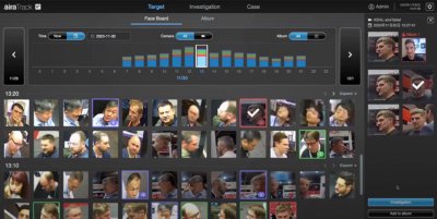
AIRA Corporation
2.17k
0
AI / AIoT
airaTrack- Facial Tracking Solution
airaTrack is a comprehensive personnel tracking system that utilizes AI algorithms developed by our team to extract features from both the "face and figure." It generates unique biometric IDs with a recognition accuracy of up to 99%, all without the need for registering facial data, addressing privacy concerns. Capable of cross-camera searches and matching 10,000 faces per second, it significantly enhances the efficiency of traditional manual matching processes and increases search efficiency and accuracy by 97% enabling automatic path tracking of personnel in the field. The system also generates investigation reports for evidential preservation.
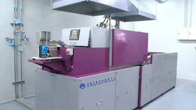
Metal Industries Research & Development Centre
2.20k
0
Smart Manufacturing
The Continuous Type Heat Treatment System Equipment for Micro Parts(CMHT)
Specially for micro parts with a diameter less than 2mm, the CMHT is equipped with integrate automatic feeding system, automatic monitoring and carburizing quenching furnace for real-time adjustment, innovative oil tank, collecting device and intelligent digital services. It provides the heat treatment industry with customized, intelligent production solution. Its advantages are as follows
‧ CMHT has 100% collecting rate (50~60% for traditional equipment), 99% yield rate (50~65% for traditional one).
‧ CMHT reduces heat treatment schedule from 30 days to 2 days only. Based on demand, CMHT can rapidly replace process modules to substitute whole traditional heat treatment equipment and price of CMHT is only half of traditional one.
‧ Introducing intelligent digital service function, CMHT transforms experiences of traditional equipment into data decision, reduces reliance on human experiences, sets up industrial IoT solution and provides heat treatment industry with smart manufacturing via cloud services.
‧ Won the international honor of R&D 100 Awards and Edison Awards.
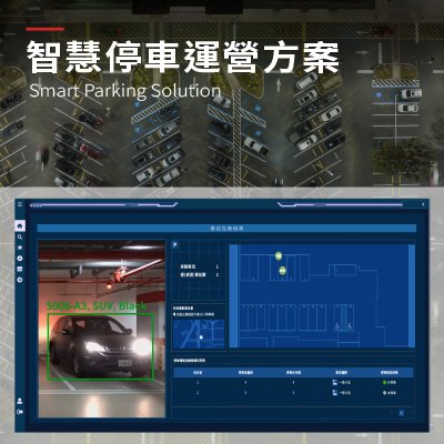
Ability Intelligent Corporation
651
0
Smart Transportation
Smart Parking Solution
The innovative parking operations solution integrates AI-based Automatic Number Plate Recognition (ANPR), sensing devices, IoT infrastructure, and a cloud management platform. By streamlining parking management, reducing manual intervention, and providing actionable insights through real-time data, this solution helps parking operators maximize space utilization and enhance customer satisfaction with a transparent, data-driven, brilliant parking service.
The system provides real-time visibility into vehicle entry and exit, space occupancy, and on-site traffic flow. It supports ticketless access and license plate–based payment. It also offers real-time parking guidance and multiple payment options. These features reduce labour costs and enhance the user parking experience. A centralized management platform and operational data analytics give operators insights into traffic patterns, space turnover, and revenue performance. This enables informed decisions on pricing strategies and space allocation. As a result, operators can achieve efficient, sustainable smart parking operations.
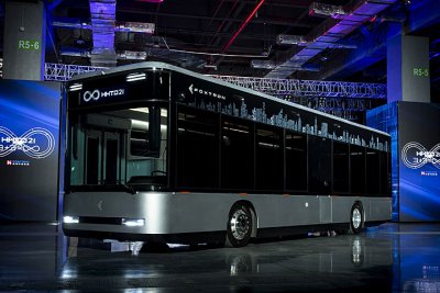
Hon Hai Precision Industry Co.,Ltd.
1.89k
0
Smart Transportation
Low Entry Electric bus- Model T
The technical solution of Foxtron Electric Bus combines domestic and international resources, each contributing its strengths:
1. It adopts Foxtron's self-developed VCU software, integrates and develops the EEA architecture for electric buses, and utilizes motors, batteries, and chassis suspension systems from international major manufacturers. In collaboration with domestic manufacturers, Foxtron designs and develops dedicated low-floor bus frames for chassis cooperation.
2. In the product design of electric buses, Foxtron identifies pain points in traditional buses and improves upon them. For example, traditional buses often have issues with rollover protection and numerous blind spots, as well as differential wheel rotation caused by wheelbase, leading to frequent traffic accidents due to visibility problems. To address these issues, Foxtron employs Computer-Aided Engineering (CAE) and NVH (Noise, Vibration, and Harshness) analysis to verify the design of various systems and components. This ensures the overall strength of the vehicle body and chassis, enhances passenger safety, and incorporates features such as panoramic image display and an electronic wide-angle rearview mirror with a blind spot detection system to solve driver blind spot issues. Additionally, to alert pedestrians and other road users to the risk of differential wheel rotation, Model T projects prominent light beams onto the ground during turns, marking the danger zone.

Far EasTone Telecommunications Co., Ltd.
28.14k
2
5G Telecommunication
5G Telemedicine Solution
Leveraging world-class 5G and advanced technologies, FET has built a “5G Telemedicine Platform” to deliver mobile, zero-day telemedicine services. This year, 5G telemedicine has expanded to 15 counties and 59 districts. During the COVID-19 pandemic, we also supported hospitals in providing remote clinical services and maintaining routine medical care.
Features
Real-time telemedicine services to strengthen medical resources in remote areas
Support for medical IoT devices
High-level system integration with hospital workflows
Newly introduced patient functions to meet epidemic-related demands
AI-powered analysis to assist physicians in diagnosis
Full-time video recording to ensure doctor-patient trust and information security
Support for virtual NHI cards
Awards & Certifications
• 2026 Taiwan Excellence Award – The highest honor for product innovation and superior quality
• 2025 National Industrial Innovation Award – First telecom company to win in 18 years
• 2025 Yang Award – Sole telecom winner for smart healthcare innovation
• British Chamber of Commerce in Taipei – Better Business Award 2025
• Certified with U.S. HIPAA for global data security compliance
• Holds ISO 27001, ISO 27017, ISO 27018, and ISO 27701 certifications
意藍資訊股份有限公司
2.15k
3
AI / AIoT
eLAND X AI
eLAND specializes in intelligent data enriched with AI analysis, offering solutions through a Software as a Service (SaaS) model. Our product series are as listed below.
Cloud Services, including OpView—the largest social listening platform offering business insights in Taiwan; PeopleView—describing the target market with AI while enhancing value of the customer database; and ECView, which monitors products in real-time across global e-commerce websites.
For Intelligent Data Solutions, we tailor AI to diverse business needs. This includes AI Search for EC, the next-generation search engine and tagging system specifically designed for e-commerce, and AI Search for KM, which Integrates generative AI, search engine, and NLP technologies to deliver knowledge search and knowledge QA services.
Within the Search Engine and NLP, our in-house technology excels in processing billions of unstructured data while maintaining exceptional efficiency, to fulfill customer's needs in digital era.
 、Firefox
  、Edge
、Edge  瀏覽器!
瀏覽器!