solution(180)
Taiwan Optical Platform
478
0
Smart Home
AI-Integrated Solutions for Smart Disaster Prevention and Site Safety
This project integrates cable TV systems, Civil IoT, and AI video recognition technology to build smart disaster prevention and site safety services. Centered on set-top boxes (STB) and intelligent sensing, the solution focuses on bridging the gap in real-time information and safety protection for elderly and rural populations.
Through its wired network infrastructure, the system developed under this project is capable of delivering real-time disaster prevention information, including earthquakes, typhoons, and heavy rainfall alerts. In addition, AI-based recognition capabilities have been integrated into the system.
Currently, the system has completed event recognition functions such as parcel placement and retrieval detection. It also performs analysis of human movement trajectories and abnormal group behavior detection. In the future, the system will be further expanded to identify dangerous situations such as violent behavior.
Through this project, Taiwan Optical Platform (TOP) demonstrates the potential of integrating cable television networks with AI and IoT technologies to develop a platform for smart disaster prevention and public safety applications.
Metal Industries Research & Development Centre
2.46k
0
Smart Manufacturing
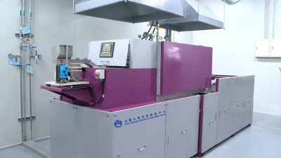
The Continuous Type Heat Treatment System Equipment for Micro Parts(CMHT)
Specially for micro parts with a diameter less than 2mm, the CMHT is equipped with integrate automatic feeding system, automatic monitoring and carburizing quenching furnace for real-time adjustment, innovative oil tank, collecting device and intelligent digital services. It provides the heat treatment industry with customized, intelligent production solution. Its advantages are as follows
‧ CMHT has 100% collecting rate (50~60% for traditional equipment), 99% yield rate (50~65% for traditional one).
‧ CMHT reduces heat treatment schedule from 30 days to 2 days only. Based on demand, CMHT can rapidly replace process modules to substitute whole traditional heat treatment equipment and price of CMHT is only half of traditional one.
‧ Introducing intelligent digital service function, CMHT transforms experiences of traditional equipment into data decision, reduces reliance on human experiences, sets up industrial IoT solution and provides heat treatment industry with smart manufacturing via cloud services.
‧ Won the international honor of R&D 100 Awards and Edison Awards.
Ability Intelligent Corporation
846
0
Smart Security
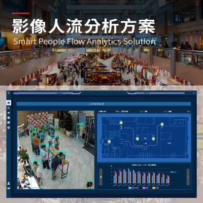
Smart People Flow Analytics Solution
Live crowd movement information is crucial in busy public spaces. Manual checks and basic sensors often lack accuracy and fail to keep up with real-time changes. The People Counting System uses AI video analytics and multi-sensor fusion. It delivers accurate, real-time crowd data. The system automatically counts people, tracks direction, monitors density, and provides instant alerts and reports. Deep learning ensures accuracy in low-light or crowded conditions. Multi-target tracking prevents double-counting.
Edge computing and cloud-based management enable on-site analysis and long-term monitoring. Integrating cameras, infrared, Wi-Fi, and Bluetooth data improves detection and increases coverage. The system generates real-time heat maps, flow analyses, and historical records. These support layout optimization, entry regulation, evacuation planning, and efficiency. The system serves malls, transit hubs, campuses, parks, and public buildings. It is vital for smart cities. It replaces manual counting with intelligent management for better safety, responsiveness, and adaptability.
HAMASTAR TECHNOLOGY CO., LTD.
631
1
Smart Transportation
Smart Mobile Inspection System
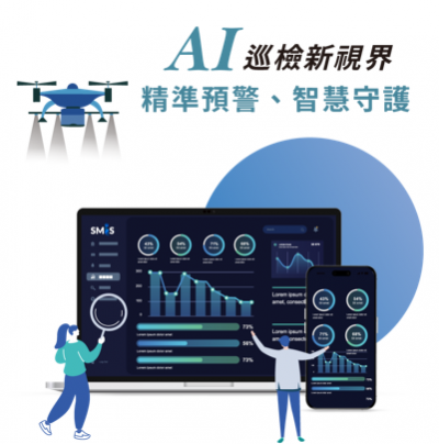
Across urban and industrial environments, public facilities, critical assets, and infrastructure systems are often highly complex and geographically dispersed. Even minor abnormalities, if not identified and addressed in time, can lead to safety risks and operational disruptions. The Smart Mobile Inspection System is designed to address these challenges, enabling governments and enterprises to establish forward-looking digital inspection and maintenance management capabilities.
The system integrates mobile devices, sensor data, and visual information, leveraging real-time AI analysis and anomaly detection to transform potential risks into predictable, traceable, and actionable management tasks. From anomaly alerts and intelligent task assignment to on-site reporting and final verification, the platform seamlessly connects every stage of the inspection workflow, delivering a fully digital, end-to-end inspection and maintenance management solution.
Taiwan AI Cloud Corporation
1.83k
0
AI / AIoT
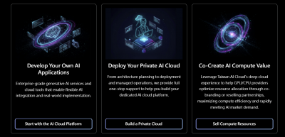
AI Compute Foundry
Taiwan AI Cloud AI Compute Foundry solution provides one-stop AI infrastructure services.
Assist governments, enterprises, and the global GPU market in driving the development of sovereign AI.
Empower enterprises to build customized AI compute centers with their own AI infrastructure, data governance, and model operation environments.
We provide complete AIHPC deployment, integration, and maintenance services, supporting private, public, and hybrid cloud architectures.
Acer ITS Incorporated
2.77k
2
Smart Transportation
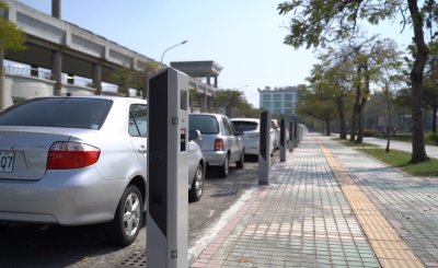
Smart Parking Meter System
Acer ITS self-develop smart parking meter system provides vehicle detection, license plate recognition, auto-ticketing, multi-payment functions to achieve the goal of payment automation for roadside parking. It also provides instant parking space information so that drivers can see the parking availability through mobile APPs to avoid circling in the city that causing traffic jam and higher carbon emissions. It collects parking information through auto-ticketing system, and feeds in big data platform to produce accurate turnover rate and usage rate. These data are the base of policy making for parking authorities. Applications with automation, intellectualization and mobilization provide drivers with nice parking experiences, and enhance parking management performance for parking authorities. Let smart parking become new smart city indicator for satisfied people and high performance government.

BRAVO IDEAS DIGITAL CO., LTD.
444
0
AI / AIoT
Citora.ai: The First AI-Powered GEO Platform
SEO is dead. GEO is the future. Consumers no longer click links — they ask AI for answers. Will your brand show up?
Citora.ai is a Generative Engine Optimization (GEO) platform built for the AI era, ensuring your brand gets mentioned and recommended by ChatGPT, Gemini, and other AI engines.
Our proprietary Generate-Test-Optimize loop automatically translates your content into AI-native language, monitors your brand's visibility and ranking across AI engines in real time, and tracks competitor movements to deliver precise optimization strategies.
In the world of AI, citations build trust, and recommendations drive traffic. Citora.ai helps you capture the AI search advantage — and stay ahead.

Administration for Digital Industries, moda
4.34k
4
Smart Governance
Go Digital
Smart City Development Project Solutions
1、Linking Publishing Company:LINKING AI BOOKS
2、King One Interactive Technology:L’AiR TAG
3、IoT Intelligent Technology:Smart Intersection AI-Powered Car-Free Green Light Switching System
4、Cosmofii:AI SOLLY Social Skills Practicing Companion
5、Environmental Management Consultant Technologies:Smart Vertical Integration Cloud Service Platform for the Rice Industry Chain
6、Keypasco:Keypasco
7、eZoom Information:The intelligent firefighting auxiliary decision-making scheme
TAIWAN SECOM CO., LTD.
11.19k
4
Smart Transportation
Intelligent Transportation Solutions
Building a Intelligent Transportation Network
The traffic system is the artery of an urban development. To improve traffic quality and build a intelligent transportation network, Taiwan SECOM is working with local governments to promote smart street lights. The brightness of these lights can be adjusted according to the surrounding environment, which not only conserves energy but also reduce traffic accidents caused by insufficient lighting. A traffic flow detection system can immediately analyze the traffic flow of each main path and the substitute routes can be immediately displayed on the display to effectively divert traffic flow. The geomagnetic sensor and smart parking meter will help you live occupancy reoporting and fee calculation.
Smart Street Light
.Smart Lighting: adjusts brightness according to various scenarios.
.Traffic detection: optimizes traffic routing and analyzes traffic flows.
.Environmental Sensing: detects the temperature, humidity, and PM 2.5 levels.
Smart Parking Meter
.Live ocupancy reoporting and fee calculation.
.Bill pringting and support third party payment.
.Significantly reduce the labor cost of road side billing by more than 50%.
Taiwan AI Cloud Corporation
472
0
AI / AIoT
On-Demand Al Cloud
Delivering fast-to-deploy, locally hosted high-performance computing and cloud platform services — empowering AI training and deployment, business application development, data storage and backup, as well as compute resource reselling.
Deliver cost-effective GPU and CPU computing powercombined with an intuitive cloud platform, enabling rapid provisioning, flexible deployment, elastic scheduling, and seamless scaling. Powered by Taiwan AI Cloud’s optimized AI runtime environment, large-scale AI workloads are executed with speed and efficiency.
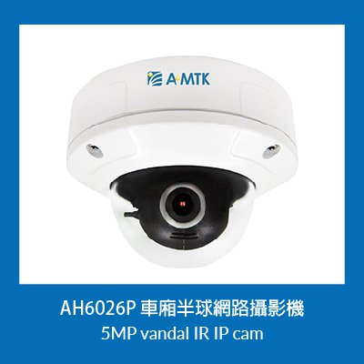
A-MTK Co., Ltd.
469
0
Smart Security
Taiwan Railways Station Access Control and Surveillance Integration System
A-MTK Expands Presence in TRA Stations 2025 Project Installation Scope: Zuoying, Neiwei, Museum of Fine Arts, Gushan, Sankuaicuo, Kaohsiung, Minzu, Science and Technology Museum, Zhengyi, and Fengshan Stations To enhance station security and management efficiency, ten TRA stations in Kaohsiung will be newly equipped with A-MTK IP cameras, expanding surveillance coverage and integrating with the access control system. The project achieves the following outcomes:
Video Surveillance Deployment: Multi-point installation of A-MTK IP cameras inside and outside stations, providing real-time monitoring, event recording, and playback.
Access Control + Video Integration: When an abnormal access event occurs (such as unauthorized card use or forced door opening), the system automatically pops up the corresponding camera feed and simultaneously sends an alarm notification to the management center.
Centralized Monitoring Platform: The Kaohsiung control center can instantly oversee access control status and video feeds, achieving cross-station integrated management.
Cybersecurity and Reliability: A-MTK is ISO 27001 certified; IP cameras are CE/FCC/BSMI certified. With system disconnection recovery, continuous operation is ensured without interruption.
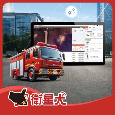
EUPFIN Technology Co.
759
0
Smart Transportation
Fire Emergency Response & Video Integration Platform
Eup has developed a comprehensive video integration platform tailored for fire and emergency rescue operations.
By connecting vehicle GPS, 360-degree cameras, body-worn cameras, and drone footage, command centers gain real-time, multi-angle situational awareness. This significantly enhances decision-making accuracy and frontline personnel safety—using technology to protect those at the very front line of emergency response.
Unified Information Platform: Integrates ground-level and aerial perspectives to deliver complete emergency intelligence.
Real-Time Command & Dispatch: Live video streaming ensures commanders stay fully informed of frontline conditions.
Enhanced Responder Safety: Real-time monitoring of firefighter environments to predict risks and provide timely support.
Cloud Video Backup: Secure cloud storage for rescue footage and operational records.
 、Firefox
  、Edge
、Edge  瀏覽器!
瀏覽器!