solution(180)
Leo Systems, Inc.
253
0
Smart Healthcare
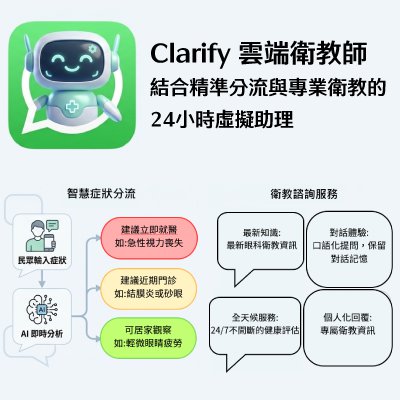
Clarify Care Guide
For Healthcare (Clarify Care Guide): Provides "Ubiquitous Support." acting as a 24/7 digital triage across Web, App, and Messaging platforms. It handles routine inquiries and symptom assessment, extending your medical team's reach.
Our Goal: Let AI handle the repetitive complexity, so your professionals can focus on critical quality and patient care.

International Integrated Systems, Inc.
2.81k
0
Smart Transportation
iTrafficView
IISI has a number of solutions for smart image processing, the main application areas are smart transportation, smart disaster prevention, security monitoring, etc. The main products include iTrafficView and iSurveillance.
iTrafficView is a server-based image recognition detection system that receive real-time video streaming from on-site network cameras and instantly performs image recognition and event detection to provide monitoring services immediately. Furthermore, the system records related identification and detection data for consecutive statistical and analysis procedure.
The advanced hybrid DVR and intelligent management platform offers a one-stop solution to enhance both analog, digital, and IP convergence. "iSurveillance" is an intelligent Hybrid DVR that supports analog and IP cameras. It applies the ASF compression for efficient data management, flexible and compatible with various brands of surveillance devices.
Nantou County Goverment
323
0
Smart Governance
Nantou Sustainable Tourism Development Plan
In alignment with global sustainable tourism trends and Taiwan’s “2050 Net-Zero Emissions Pathway,” Nantou County launched the Nantou Sustainable Tourism Campaign (NSTC) in 2024 in partnership with National Chi Nan University. As the first local government in Taiwan to establish a comprehensive sustainable tourism framework, Nantou created NSTC as a platform for training, talent development, knowledge exchange, and strategic marketing to accelerate tourism transformation.
NSTC is built on three core pillars. NSTC Talk enhances industry capacity through workshops, training programs, and forums. NSTC Criteria incorporates international sustainable tourism standards to develop localized evaluation guidelines and assess business sustainability maturity. NSTC Travel Guide promotes certified businesses and sustainable itineraries, encouraging responsible travel and green consumption.
Through systematic carbon footprint assessments, Nantou has developed nine net-zero itineraries and twenty-three low-carbon routes, covering one- to three-day immersive experiences. These itineraries adopt the internationally recognized Gold Standard carbon offset mechanism to ensure measurable emission reduction.
By integrating data-driven governance with green practices, NSTC positions Nantou as a leading model for sustainable tourism transformation and low-carbon regional development.
Kaohsiung City Government
3.15k
0
Smart Security
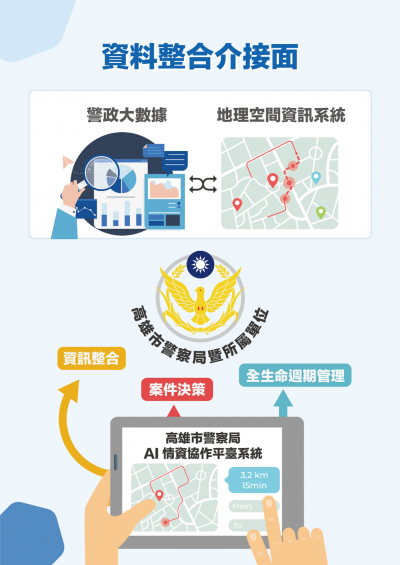
3D street violence early warning, AI intelligence collection and integration platform.
Criminal and street violence cases will affect and cause panic to citizens. In order to diminish street violence cases, reducing the time to solve these cases, protecting citizens’ lives and properties, and allow citizens to live without fear, the Kaohsiung City Police Department (KCPD) built the “3D Street Violence Early Warning, AI Intelligence Collection and Integration Platform” (hereinafter called “the Platform”). The platform utilizes the Internet of Things (IoT) to combine AI image recognition and sound sensing technologies for cross-domain big data analyses.
KCPD established cross-platform data interfacing and integration, mainly through “data integration” and “network analyses” to collect with the municipal government’s transportation bureaus and social bureaus; and import existing data from the KCPD data platforms. The Platform will, through web service API, (a) retrieve data built by information systems, (b) conduct big data analysis, aggregate applicable intelligence data and present it in the form of dynamic information, (c) Integrate all information and display it as maps and topologies, improve case handling efficiency. According to KCPD employees’ query, they can adjust factor weights and relationships. Analyze the results based on rational mathematical models and professional case-handling concepts, so that intelligence analysis goes beyond the limitations of platform developers and allows criminal police to maximize their capabilities.
TAIWAN SECOM CO., LTD.
10.91k
4
Smart Transportation
Intelligent Transportation Solutions
Building a Intelligent Transportation Network
The traffic system is the artery of an urban development. To improve traffic quality and build a intelligent transportation network, Taiwan SECOM is working with local governments to promote smart street lights. The brightness of these lights can be adjusted according to the surrounding environment, which not only conserves energy but also reduce traffic accidents caused by insufficient lighting. A traffic flow detection system can immediately analyze the traffic flow of each main path and the substitute routes can be immediately displayed on the display to effectively divert traffic flow. The geomagnetic sensor and smart parking meter will help you live occupancy reoporting and fee calculation.
Smart Street Light
.Smart Lighting: adjusts brightness according to various scenarios.
.Traffic detection: optimizes traffic routing and analyzes traffic flows.
.Environmental Sensing: detects the temperature, humidity, and PM 2.5 levels.
Smart Parking Meter
.Live ocupancy reoporting and fee calculation.
.Bill pringting and support third party payment.
.Significantly reduce the labor cost of road side billing by more than 50%.
TECO
3.88k
0
Smart Transportation
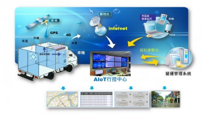
AI Video Control Center
ITTS Smart Logistics Solution-AI Video Control Center, from the perspective of practitioners, uses a smart management system to help the logistics company master the three major information of people, vehicles and parcel.
The main features are:
APP-based mobile control, Smart phones can provide anytime & anywhere control capability
Dynamics Video + image real-time monitoring, real-time conditions of vehicles moving and stopping are clearly visible
Visualization of data reports, clear operational information such as fuel consumption rate and delivery rate at a glance
AI intelligent interpretation, real-time reminder for driving violation judgment, reduce the violation rate, and provide a safe driving environment
The accumulation of AI machine learning can be extended to several aspects in the future:
For drivers-through driving behavior interpretation, the driver's condition can be found immediately to prevent dangerous driving; automatic routing suggestions to help novice drivers quickly get started and reach the level of mature delivery
The city management can share real-time road conditions images or video, reflect road level and post-disaster road conditions, and street management capabilities
Provide scientific and technological law enforcement capabilities to localities-image recording of license plate recognition can assist police units in investigating cases
A-MTK Co., Ltd.
3.16k
2
Smart Transportation
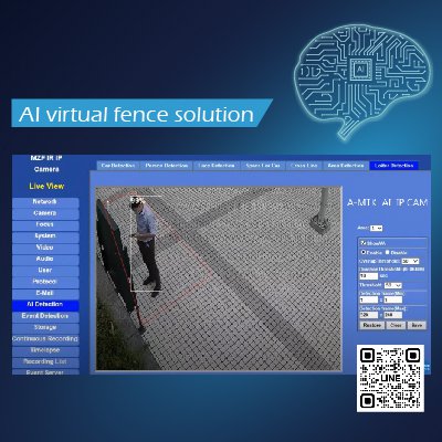
AI virtual fence solution
A-MTK is IP cams manufacturer in Taiwan, and complete virtual fence solution with IP cams equipped with edge AI computing, edge alarm notification, and back-end NVR pop-up notify. A-MTK virtual fence solution is simple to set up, cost-effective, and can be applied to factory perimeter, campus perimeter, hazardous area protection.... etc. A-MTK virtual fence allows users to set up "Hand-drawn Shape Warning Zone", "Cross-line Detection", and "Personnel Loitering Detection" for different scenarios. No matter day or night, color or black and white, it can have the best personnel detection effect.
After detecting the personnel, it can provide sound and light alarms at the IP cam edge-end. In the same time, the solution cooperates with the administrator's office to make remote alarms with A-MTK NVR software.
Wave-In Communication
3.36k
0
Smart Award
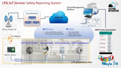
Liquefied Petroleum Gas (LPG) IoT Solution
1) Automatic Notification System
1. Consolidate the IOT info from various sensors, as well as history of user behaviors
2. Big Data Analytics & AI-enabled recommendation engine: Send delivery notice or abnormal alert
3. Push mobile APP message to User and Operator
2) Electronic Ordering System (Customized)
1. Planed delivery schedule service, user confirmed the delivery time, system automatically plans routing and deliveryman
2. Delivery schedule: Push individual mobile APP message to each deliveryman
3) Cylinder Management System (Customized)
1. Cylinder barcode APP scanning, Deliveryman scan the barcode and upload to cloud system
2. Automatic notification mechanism for expired cylinder
3. Data Analytics & Statistical Report
4) Safety Reporting System
1. LPG safety sensors: Including gas detector, Solenoid Valve, pressure switch and UVIR Flame Detector
2. IOT-BOX showoff Solenoid Valve and reporting
3. Push mobile APP message to User and Operator for emergency response
5) Cloud ERP System (Customized)
1. Modular management system: Accounting, Administrative, Financial, Procurement, Human Resource, inventory, Customer Service and sales management
2. Data collection, Analytics & Statistical Report

Qualcomm Incorporated
326
0
Smart Transportation
Qualcomm® Terrestrial Positioning Service
Qualcomm Terrestrial Positioning Service (TPS) provides high-accuracy geolocation and wayfinding capabilities for mobile and industrial devices by leveraging nearby Wi-Fi, cellular base stations, and terrestrial signals such as Bluetooth® Low Energy (BLE), enabling precise positioning virtually anywhere. It offers flexible integration options through software packages and APIs that can be easily incorporated across diverse hardware and platforms. Designed with battery efficiency in mind, intelligent algorithms support always-on or periodic cloud-based location updates, optimizing power consumption for different usage scenarios. TPS also supports offline positioning through token and caching technologies, allowing devices to determine location even without network connectivity.
* Qualcomm branded products are products of Qualcomm Technologies, Inc. and/or its subsidiaries. Qualcomm is a trademark or registered trademark of Qualcomm Incorporated.
Light Matrix Inc.
1.78k
0
Smart Education
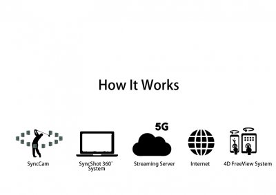
360 Free view system—three-dimensional strike zone with 5G smart baseball field establishment
Baseball enjoys widespread popularity in Taiwan, and our cutting-edge 5G live streaming technology elevates the sport to a new level. Through real-time 360-degree tracking, we present a three-dimensional strike zone, delivering an unprecedented viewing experience. This innovation not only enhances the enjoyment for spectators but also serves as a valuable tool for training. Coaches and sports science teams can leverage precise multi-angle recordings to analyze and optimize player movements, effectively contributing to enhanced athletic performance.
Fashion Intelligence Co.,Ltd.
3.54k
1
Smart Transportation
Indoor Positioning Navigation
【Taipei Main Station Navigator APP】
Taipei Main Station covers four major railway systems: Taiwan Railway, Taiwan High Speed Rail, Taipei Metro and Taoyuan Metro. The complexity of the internal route has led Taipei Main Station to be dubbed the largest underground maze in Taiwan. Not only are outsiders prone to getting lost, but Taipeiers are not even aware of it.
We launched Taipei Navi App to private the function of Indoor navigation, tasty food and shopping, intelligent parking, and push notification. It's easy for people to know where they are and find their destination
【Taipei Songshan Airport】
The Airport Terminal Building is 61,000 square meters. Managers take time to confirm position and execution status when assigning tasks and events. With this Staff Positioning and Dispatching System, managers can assign work. Employees see the location and content and can report the status of completion on the system. The manager can check whether the employee actually arrived at the given location.

Fashion Intelligence Co.,Ltd.
5.10k
0
Smart Transportation
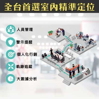
Intelligent Positioning System
Intelligent Positioning System can remotely track the paths, remotely set the access authority, and provide the access alarm and SOS alarm based on configured location Bluetooth sensors. There are three applications:
[Guardian Wristband]
Authority can know whether home quarantine people are at home. Through the beacon wristband connects with receiver. If home quarantine people are leaving home, the system will send notification to the authority.
[Indoor Navigation]
Locate users’ position via Bluetooth and precede indoor navigation to let users know their position and find the way in building. This service is applicable to large areas such as airports, stations, department stores, etc.
[Intelligence on People Seeking]
With smart positioning wristband, users can instantly know current location of their children or parents via App. It could avoid the common problem of missing family.
 、Firefox
  、Edge
、Edge  瀏覽器!
瀏覽器!